SLGA Cloud Optimised GeoTiff DataStore
The datasets listed here comprise the TERN Landscapes Cloud Optimised Geotiff Datastore (COGs). Navigate the links below to access the various publicly available data sets. COGs allow you to quickly and efficiently access and view large raster datasets over the web without having to download the entire data set locally. Portions of, or the entire data set, can also be downloaded as required. Examples of accessing COGS can be found BELOW.
To access the SLGA data products you need to generate an API key. See BELOW for instructions.
| SLGA | Soil and Landscape Grid of Australia | more info | Nicely formated access | Raw access |
The covariates used in the soil attribute surface modelling can be accessed from the links listed below. Metadata for the individual covariate rasters can be found HERE. A metadata record for the entire covariate dataset can be found at - https://doi.org/10.25919/jr32-yq58
| 90m Covariates | 90m resolution geotiffs for use in Digital Soil Modelling | more info | Nicely formated access | Raw access |
| 90m PCA Covariates | 90m resolution Principal Component geotiffs for use in Digital Soil Modelling | more info | Nicely formated access | Raw access |
| 30m Covariates | 30m resolution geotiffs for use in Digital Soil Modelling | more info | Nicely formated access | Raw access |
| 30m PCA Covariates | 30m resolution Principal Component geotiffs for use in Digital Soil Modelling | more info | Nicely formated access | Raw access |
If you are using the R programming language, you can download a package from GitHub called SLGACloud to help with accessing the COGs URLs and metadata information
Accessing Cloud Optimised GeoTIFFS
COGs are GeoTIFF files that are internally formatted to allow efficient access to the raster data across the web. This means you can quickly and efficiently access and view large raster datasets over the web without having to download the entire data set locally. Portions of, or the entire data set, can also be downloaded as required.To access the SLGA soil attribute products hosterd by TERN, users need to create an account and generate an API key to access the TERN data APIs by visiting the TERN accounts page. Once you have created your TERN account you can generate an API key here or clicking on the arrow in the top right of the accounts page. Make sure you save this key somewhere when you first create it as you can't see it again after you leave the api key create page.
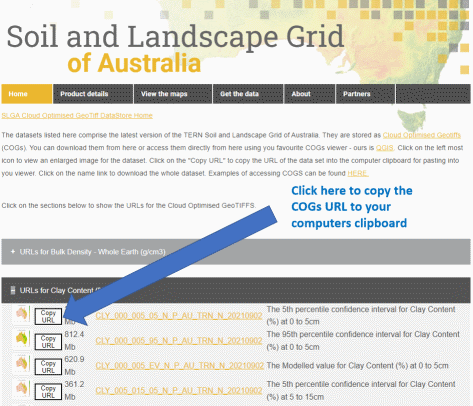
Next step is to go to the top of this page to find the URL of the product you are wishing to access. For this example click on the "Nicely formated access" link in the SLGA table to go to the SLGA COGs URLs page (image below). Click on the "Copy URL" button to copy the COG URL to your computers clipboard.
COGs in QGIS
QGIS is a GIS client which is able to utilise COG raster data sources.
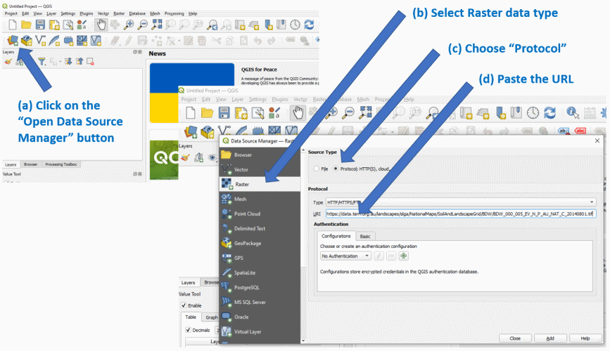
Click on the (a) “Open Data Source Manager” button to open the data source dialog window. Then (b) select "Raster" data source in the left side menu. (c) Next select the "Protocol" option in the "Source Type" box. Normally You would then just (d) paste the URL into the "URI" box and click the "Add" button and the raster would be diplayed. BUT, because the TERN Data Store requires authentication we need to supply our credentials with each data request. To do this we simply add them to the COGS URL as per below -
https://The "YourApiKey" in the above URL is the API Key you obtained from TERN as per above.
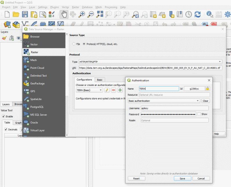
To avoid doing this every time you wish to access a dataset, QGIS can store these credentials for you and automatically inject them into the URL for you, as per below. Click on the "+" button in the "Authentication" box and fill in the Name - Whatever you want to call it, Username - it needs to be "apikey" and Pasword - which is the API Key you obtained from TERN. Then click "Save". Now when you want to access TERN Data Store COG files, select this authentication type and it will be automatically inserted into the URL for you.
Currently the Covariate Rasters listed above do not need authentication to access them. Thus the process to access them is the same as above but you do not need to include the API Key in the URL
COGs in R
The R "terra" package (the successor to the "raster" package) is able to access COGs directly. Below are some examples of using COGs in "terra". Copy the code below in to you RStudio session or download this script.
FundersPartners


TERN is enabled by NCRIS.