90m Covariates
SLGA Cloud Optimised GeoTiff DataStore Home
The datasets listed here comprise the TERN national 90m Digital Soil Modelling (DSM) raster environmental covariate stack. They are stored as Cloud Optimised Geotiffs (COGs). You can download them from here or access them directly from here using you favourite COGs viewer - ours is QGIS. Click on the left most icon to view an enlarged image for the dataset. Click on the "Copy URL" to copy the URL of the data set into the computer clipboard for pasting into you viewer. Click on the name link to download the whole dataset and hover over the "I" icon to see extended metadata.
Click on the sections below to show the URLs for the Cloud Optimised GeoTIFFS.
 Click to enlarge the image
|
|
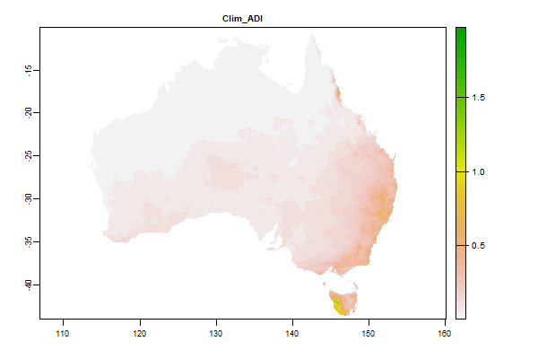
4 Gb | Clim_ADI |

Name : Clim_ADI
Description : Minimum monthly aridity index
Source : CSIRO
Metadata : https://shiny.esoil.io/Apps/Covariates?Attribute=Climate&Name=Clim_ADI&Resolution=90m
Units : index
SCORPAN : Climate
Original Resolution : 90m
|
Minimum monthly aridity index | MetaData |
 Click to enlarge the image
|
|
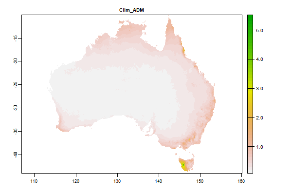
3.9 Gb | Clim_ADM |
Name : Clim_ADM
Description : Mean annual aridity index (annual precipitation/ annual potential evaporation)
Source : CSIRO
Metadata : https://shiny.esoil.io/Apps/Covariates?Attribute=Climate&Name=Clim_ADM&Resolution=90m
Units : index
SCORPAN : Climate
Original Resolution : 90m
|
Mean annual aridity index (annual precipitation/ annual potential evaporation) | MetaData |
 Click to enlarge the image
|
|
4 Gb | Clim_ADRI |
Name : Clim_ADRI
Description : Aridity Index (PT/EP) - min difference between successive months
Source : CSIRO
Metadata : https://shiny.esoil.io/Apps/Covariates?Attribute=Climate&Name=Clim_ADRI&Resolution=90m
Units : index
SCORPAN : Climate
Original Resolution : 90m
|
Aridity Index (PT/EP) - min difference between successive months | MetaData |
 Click to enlarge the image
|
|
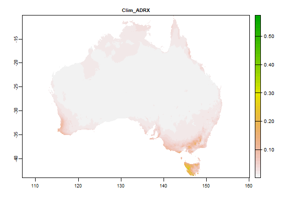
4 Gb | Clim_ADRX |
Name : Clim_ADRX
Description : Aridity Index (PT/EP)- max difference between successive months
Source : CSIRO
Metadata : https://shiny.esoil.io/Apps/Covariates?Attribute=Climate&Name=Clim_ADRX&Resolution=90m
Units : index
SCORPAN : Climate
Original Resolution : 90m
|
Aridity Index (PT/EP)- max difference between successive months | MetaData |
 Click to enlarge the image
|
|
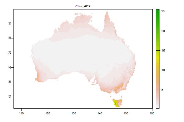
3.9 Gb | Clim_ADX |
Name : Clim_ADX
Description : Aridity Index (PT/EP)- max difference between successive months
Source : CSIRO
Metadata : https://shiny.esoil.io/Apps/Covariates?Attribute=Climate&Name=Clim_ADX&Resolution=90m
Units : index
SCORPAN : Climate
Original Resolution : 90m
|
Aridity Index (PT/EP)- max difference between successive months | MetaData |
 Click to enlarge the image
|
|
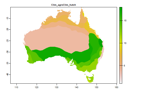
23.3 Mb | Clim_agroClim_hutch |
Name : Clim_agroClim_hutch
Description : AgroClimatic Index
Source : Unknown
Metadata : https://shiny.esoil.io/Apps/Covariates?Attribute=Climate&Name=Clim_agroClim_hutch&Resolution=90m
Units : none
SCORPAN : Climate
Original Resolution : 90m
|
AgroClimatic Index | MetaData |
 Click to enlarge the image
|
|
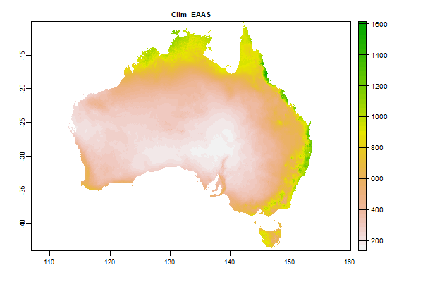
3.4 Gb | Clim_EAAS |
Name : Clim_EAAS
Description : Annual total actual evapotranspiration modelled using terrain-scaled water holding capacity (mm)
Source : CSIRO
Metadata : https://shiny.esoil.io/Apps/Covariates?Attribute=Climate&Name=Clim_EAAS&Resolution=90m
Units : mm
SCORPAN : Climate
Original Resolution : 90m
|
Annual total actual evapotranspiration modelled using terrain-scaled water holding capacity (mm) | MetaData |
 Click to enlarge the image
|
|
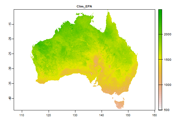
3.8 Gb | Clim_EPA |
Name : Clim_EPA
Description : Annual potential evaporation (mm)
Source : CSIRO
Metadata : https://shiny.esoil.io/Apps/Covariates?Attribute=Climate&Name=Clim_EPA&Resolution=90m
Units : mm
SCORPAN : Climate
Original Resolution : 90m
|
Annual potential evaporation (mm) | MetaData |
 Click to enlarge the image
|
|
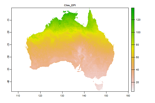
4.1 Gb | Clim_EPI |
Name : Clim_EPI
Description : Minimum monthly potential evaporation (mm)
Source : CSIRO
Metadata : https://shiny.esoil.io/Apps/Covariates?Attribute=Climate&Name=Clim_EPI&Resolution=90m
Units : mm
SCORPAN : Climate
Original Resolution : 90m
|
Minimum monthly potential evaporation (mm) | MetaData |
 Click to enlarge the image
|
|
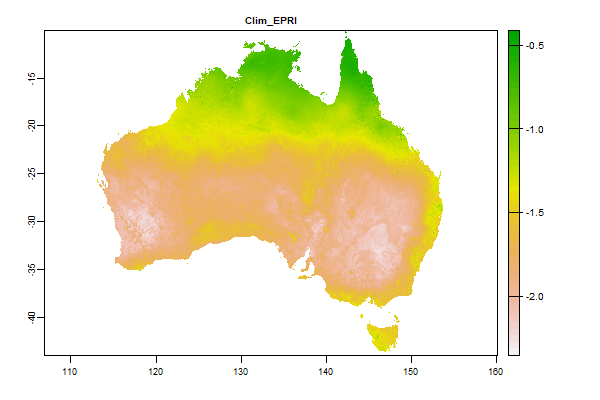
3.8 Gb | Clim_EPRI |
Name : Clim_EPRI
Description : Potential evaporation - min difference between successive months
Source : CSIRO
Metadata : https://shiny.esoil.io/Apps/Covariates?Attribute=Climate&Name=Clim_EPRI&Resolution=90m
Units : mm
SCORPAN : Climate
Original Resolution : 90m
|
Potential evaporation - min difference between successive months | MetaData |
 Click to enlarge the image
|
|
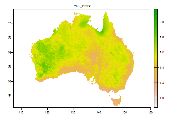
3.8 Gb | Clim_EPRX |
Name : Clim_EPRX
Description : Potential evaporation - max difference between successive months
Source : CSIRO
Metadata : https://shiny.esoil.io/Apps/Covariates?Attribute=Climate&Name=Clim_EPRX&Resolution=90m
Units : mm
SCORPAN : Climate
Original Resolution : 90m
|
Potential evaporation - max difference between successive months | MetaData |
 Click to enlarge the image
|
|
3.6 Gb | Clim_EPX |
Name : Clim_EPX
Description : Maximum monthly potential evaporation (mm)
Source : CSIRO
Metadata : https://shiny.esoil.io/Apps/Covariates?Attribute=Climate&Name=Clim_EPX&Resolution=90m
Units : mm
SCORPAN : Climate
Original Resolution : 90m
|
Maximum monthly potential evaporation (mm) | MetaData |
 Click to enlarge the image
|
|
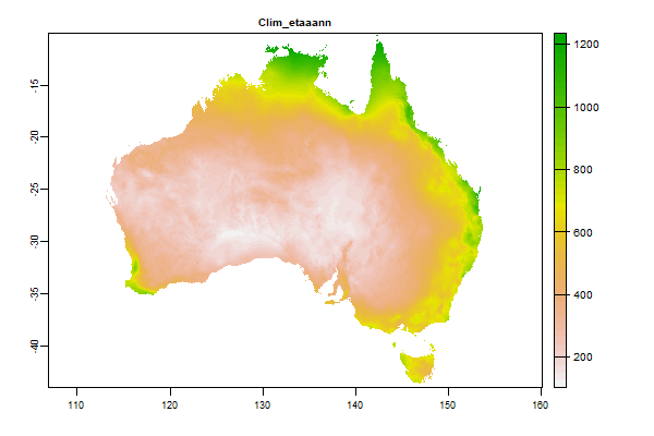
182 Mb | Clim_etaaann |
Name : Clim_etaaann
Description : Average areal actual evapotranspiration - Annual
Source : BOM
Metadata : https://shiny.esoil.io/Apps/Covariates?Attribute=Climate&Name=Clim_etaaann&Resolution=90m
Units : mm
SCORPAN : Climate
Original Resolution : 5km
|
Average areal actual evapotranspiration - Annual | MetaData |
 Click to enlarge the image
|
|
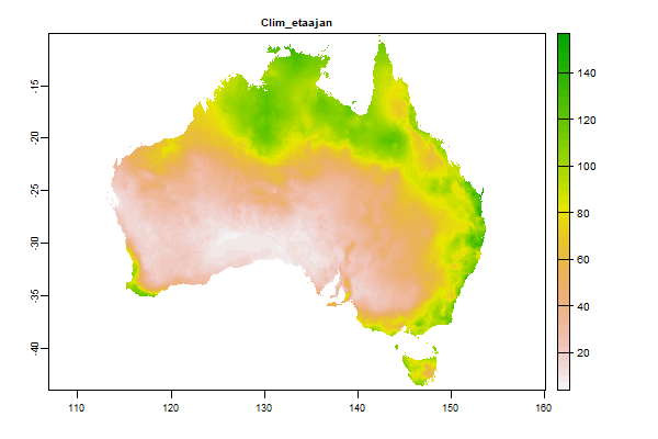
91.9 Mb | Clim_etaajan |
Name : Clim_etaajan
Description : Average areal actual evapotranspiration - January
Source : BOM
Metadata : https://shiny.esoil.io/Apps/Covariates?Attribute=Climate&Name=Clim_etaajan&Resolution=90m
Units : mm
SCORPAN : Climate
Original Resolution : 5km
|
Average areal actual evapotranspiration - January | MetaData |
 Click to enlarge the image
|
|
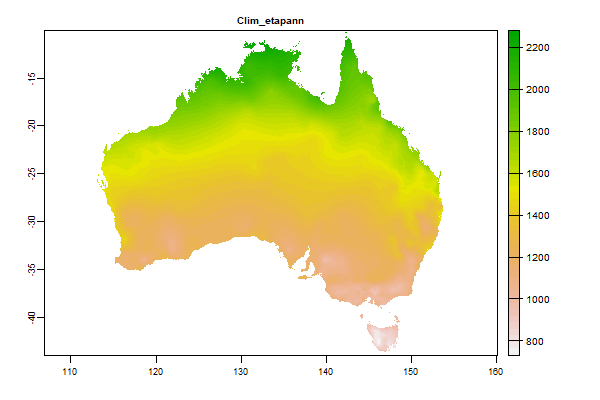
133.6 Mb | Clim_etapann |
Name : Clim_etapann
Description : Average areal potential evapotranspiration - Annual
Source : BOM
Metadata : https://shiny.esoil.io/Apps/Covariates?Attribute=Climate&Name=Clim_etapann&Resolution=90m
Units : mm
SCORPAN : Climate
Original Resolution : 5km
|
Average areal potential evapotranspiration - Annual | MetaData |
 Click to enlarge the image
|
|
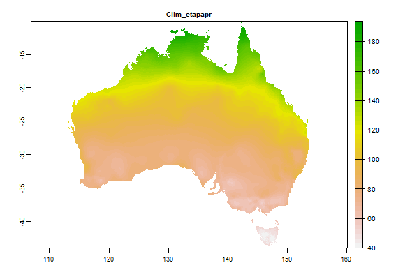
72.3 Mb | Clim_etapapr |
Name : Clim_etapapr
Description : Average areal potential evapotranspiration - April
Source : BOM
Metadata : https://shiny.esoil.io/Apps/Covariates?Attribute=Climate&Name=Clim_etapapr&Resolution=90m
Units : mm
SCORPAN : Climate
Original Resolution : 5km
|
Average areal potential evapotranspiration - April | MetaData |
 Click to enlarge the image
|
|
70.2 Mb | Clim_etapaug |
Name : Clim_etapaug
Description : Average areal potential evapotranspiration - August
Source : BOM
Metadata : https://shiny.esoil.io/Apps/Covariates?Attribute=Climate&Name=Clim_etapaug&Resolution=90m
Units : mm
SCORPAN : Climate
Original Resolution : 5km
|
Average areal potential evapotranspiration - August | MetaData |
 Click to enlarge the image
|
|
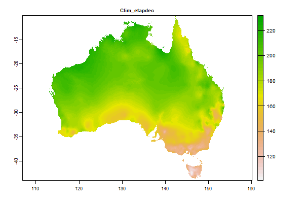
79.1 Mb | Clim_etapdec |
Name : Clim_etapdec
Description : Average areal potential evapotranspiration - December
Source : BOM
Metadata : https://shiny.esoil.io/Apps/Covariates?Attribute=Climate&Name=Clim_etapdec&Resolution=90m
Units : mm
SCORPAN : Climate
Original Resolution : 5km
|
Average areal potential evapotranspiration - December | MetaData |
 Click to enlarge the image
|
|
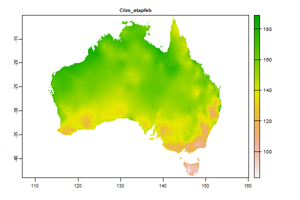
75.2 Mb | Clim_etapfeb |
Name : Clim_etapfeb
Description : Average areal potential evapotranspiration - February
Source : BOM
Metadata : https://shiny.esoil.io/Apps/Covariates?Attribute=Climate&Name=Clim_etapfeb&Resolution=90m
Units : mm
SCORPAN : Climate
Original Resolution : 5km
|
Average areal potential evapotranspiration - February | MetaData |
 Click to enlarge the image
|
|
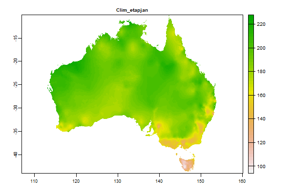
79.9 Mb | Clim_etapjan |
Name : Clim_etapjan
Description : Average areal potential evapotranspiration - January
Source : BOM
Metadata : https://shiny.esoil.io/Apps/Covariates?Attribute=Climate&Name=Clim_etapjan&Resolution=90m
Units : mm
SCORPAN : Climate
Original Resolution : 5km
|
Average areal potential evapotranspiration - January | MetaData |
 Click to enlarge the image
|
|
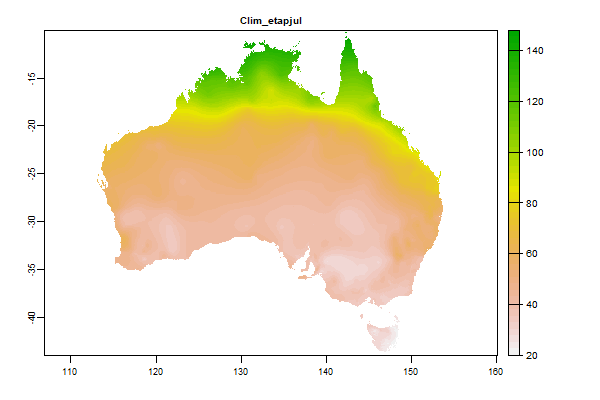
71.1 Mb | Clim_etapjul |
Name : Clim_etapjul
Description : Average areal potential evapotranspiration - July
Source : BOM
Metadata : https://shiny.esoil.io/Apps/Covariates?Attribute=Climate&Name=Clim_etapjul&Resolution=90m
Units : mm
SCORPAN : Climate
Original Resolution : 5km
|
Average areal potential evapotranspiration - July | MetaData |
 Click to enlarge the image
|
|
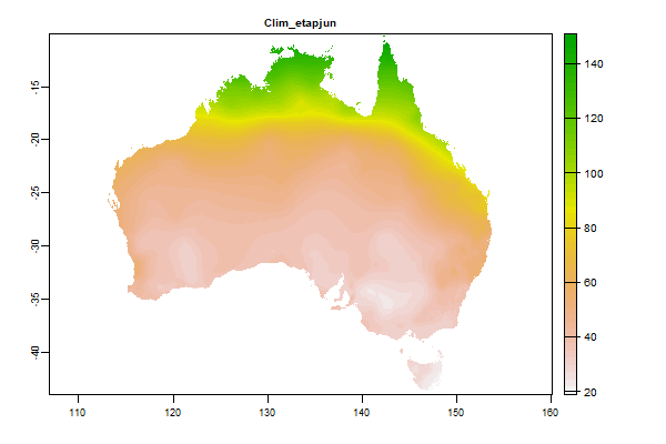
71 Mb | Clim_etapjun |
Name : Clim_etapjun
Description : Average areal potential evapotranspiration - Jun
Source : BOM
Metadata : https://shiny.esoil.io/Apps/Covariates?Attribute=Climate&Name=Clim_etapjun&Resolution=90m
Units : mm
SCORPAN : Climate
Original Resolution : 5km
|
Average areal potential evapotranspiration - Jun | MetaData |
 Click to enlarge the image
|
|
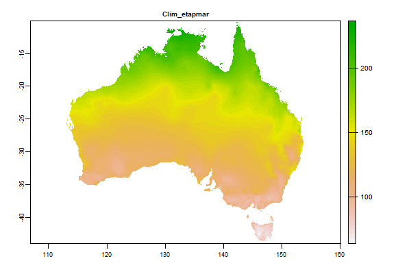
74.9 Mb | Clim_etapmar |
Name : Clim_etapmar
Description : Average areal potential evapotranspiration - March
Source : BOM
Metadata : https://shiny.esoil.io/Apps/Covariates?Attribute=Climate&Name=Clim_etapmar&Resolution=90m
Units : mm
SCORPAN : Climate
Original Resolution : 5km
|
Average areal potential evapotranspiration - March | MetaData |
 Click to enlarge the image
|
|
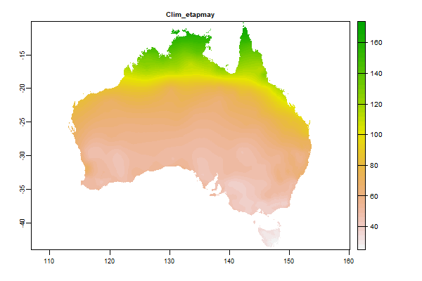
70.2 Mb | Clim_etapmay |
Name : Clim_etapmay
Description : Average areal potential evapotranspiration - May
Source : BOM
Metadata : https://shiny.esoil.io/Apps/Covariates?Attribute=Climate&Name=Clim_etapmay&Resolution=90m
Units : mm
SCORPAN : Climate
Original Resolution : 5km
|
Average areal potential evapotranspiration - May | MetaData |
 Click to enlarge the image
|
|
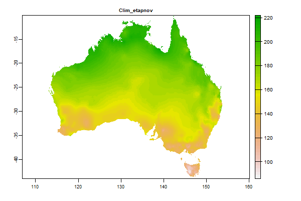
74 Mb | Clim_etapnov |
Name : Clim_etapnov
Description : Average areal potential evapotranspiration - November
Source : BOM
Metadata : https://shiny.esoil.io/Apps/Covariates?Attribute=Climate&Name=Clim_etapnov&Resolution=90m
Units : mm
SCORPAN : Climate
Original Resolution : 5km
|
Average areal potential evapotranspiration - November | MetaData |
 Click to enlarge the image
|
|
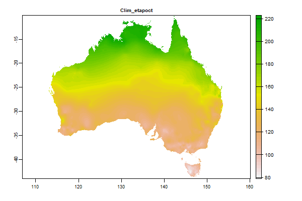
72.9 Mb | Clim_etapoct |
Name : Clim_etapoct
Description : Average areal potential evapotranspiration - October
Source : BOM
Metadata : https://shiny.esoil.io/Apps/Covariates?Attribute=Climate&Name=Clim_etapoct&Resolution=90m
Units : mm
SCORPAN : Climate
Original Resolution : 5km
|
Average areal potential evapotranspiration - October | MetaData |
 Click to enlarge the image
|
|
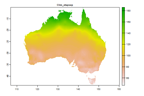
72.5 Mb | Clim_etapsep |
Name : Clim_etapsep
Description : Average areal potential evapotranspiration - September
Source : BOM
Metadata : https://shiny.esoil.io/Apps/Covariates?Attribute=Climate&Name=Clim_etapsep&Resolution=90m
Units : mm
SCORPAN : Climate
Original Resolution : 5km
|
Average areal potential evapotranspiration - September | MetaData |
 Click to enlarge the image
|
|
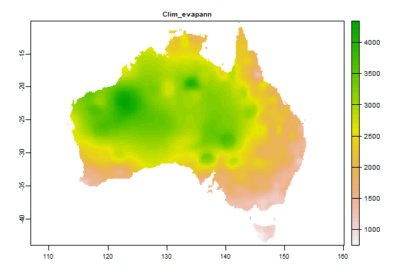
102.5 Mb | Clim_evapann |
Name : Clim_evapann
Description : Average Pan Evaporation - Annual
Source : BOM
Metadata : https://shiny.esoil.io/Apps/Covariates?Attribute=Climate&Name=Clim_evapann&Resolution=90m
Units : mm
SCORPAN : Climate
Original Resolution : 5km
|
Average Pan Evaporation - Annual | MetaData |
 Click to enlarge the image
|
|
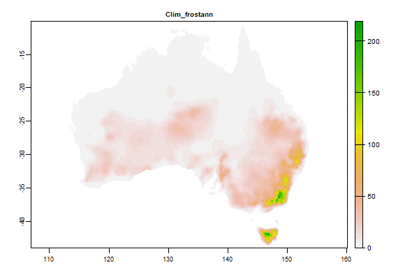
1 Gb | Clim_frostann |
Name : Clim_frostann
Description : Potential frost Days Annual
Source : BOM
Metadata : https://shiny.esoil.io/Apps/Covariates?Attribute=Climate&Name=Clim_frostann&Resolution=90m
Units : number of days
SCORPAN : Climate
Original Resolution : 5km
|
Potential frost Days Annual | MetaData |
 Click to enlarge the image
|
|
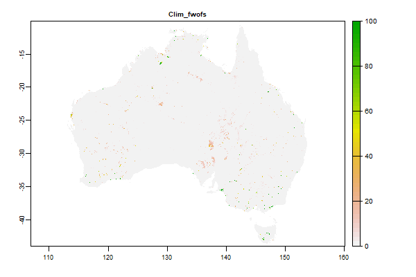
1.4 Gb | Clim_fwofs |
Name : Clim_fwofs
Description : WaterObservations from Space FRESHWATER(Split Fresh/Salt to deal with coastal systems)
Source : CSIRO
Metadata : https://shiny.esoil.io/Apps/Covariates?Attribute=Climate&Name=Clim_fwofs&Resolution=90m
Units : percent
SCORPAN : Climate
Original Resolution : 90m
|
WaterObservations from Space FRESHWATER(Split Fresh/Salt to deal with coastal systems) | MetaData |
 Click to enlarge the image
|
|
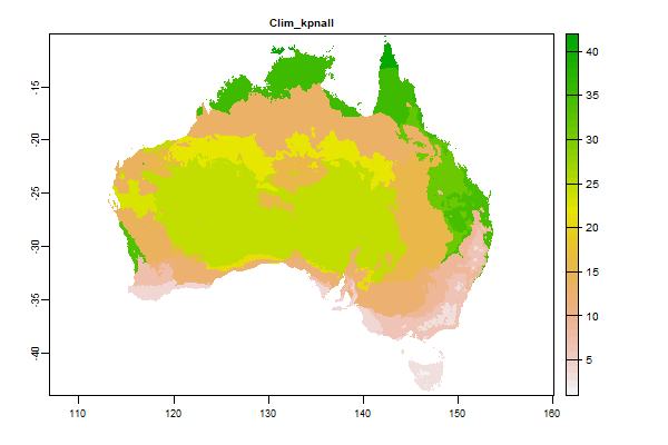
66.4 Mb | Clim_kpnall |
Name : Clim_kpnall
Description : Koppen classes
Source : BOM
Metadata : https://shiny.esoil.io/Apps/Covariates?Attribute=Climate&Name=Clim_kpnall&Resolution=90m
Units : index
SCORPAN : Climate
Original Resolution : 5km
|
Koppen classes | MetaData |
 Click to enlarge the image
|
|
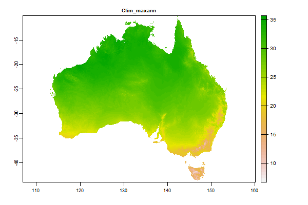
1.1 Gb | Clim_maxann |
Name : Clim_maxann
Description : Average daily max temperature - Annual
Source : BOM
Metadata : https://shiny.esoil.io/Apps/Covariates?Attribute=Climate&Name=Clim_maxann&Resolution=90m
Units : degrees celcius
SCORPAN : Climate
Original Resolution : 5km
|
Average daily max temperature - Annual | MetaData |
 Click to enlarge the image
|
|
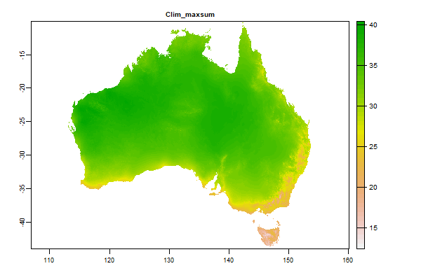
1.1 Gb | Clim_maxsum |
Name : Clim_maxsum
Description : Average daily max temperature - Summer
Source : BOM
Metadata : https://shiny.esoil.io/Apps/Covariates?Attribute=Climate&Name=Clim_maxsum&Resolution=90m
Units : degrees celcius
SCORPAN : Climate
Original Resolution : 5km
|
Average daily max temperature - Summer | MetaData |
 Click to enlarge the image
|
|
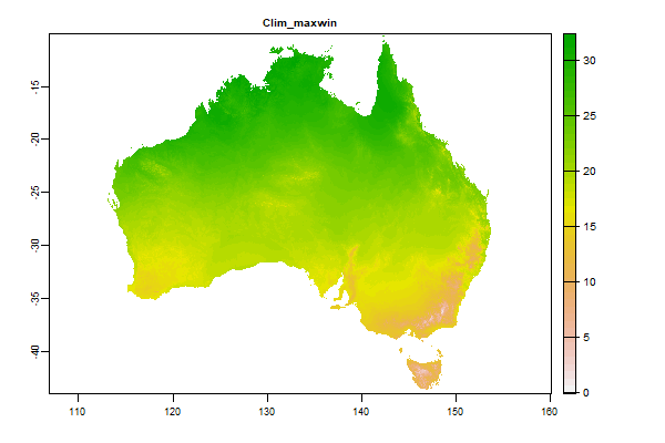
1.2 Gb | Clim_maxwin |
Name : Clim_maxwin
Description : Average daily max temperature - Winter
Source : BOM
Metadata : https://shiny.esoil.io/Apps/Covariates?Attribute=Climate&Name=Clim_maxwin&Resolution=90m
Units : degrees celcius
SCORPAN : Climate
Original Resolution : 5km
|
Average daily max temperature - Winter | MetaData |
 Click to enlarge the image
|
|
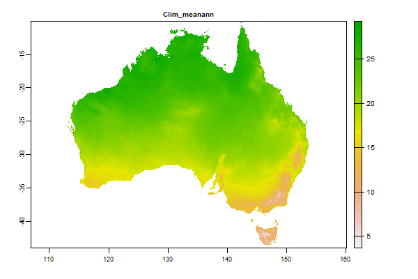
1.2 Gb | Clim_meanann |
Name : Clim_meanann
Description : Average daily mean temperature - Annual
Source : BOM
Metadata : https://shiny.esoil.io/Apps/Covariates?Attribute=Climate&Name=Clim_meanann&Resolution=90m
Units : degrees celcius
SCORPAN : Climate
Original Resolution : 5km
|
Average daily mean temperature - Annual | MetaData |
 Click to enlarge the image
|
|
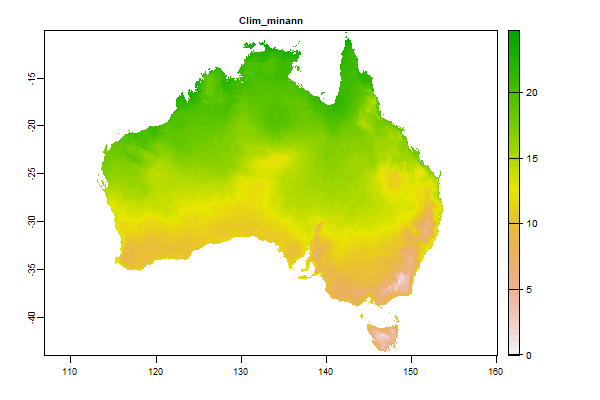
1.3 Gb | Clim_minann |
Name : Clim_minann
Description : Average daily min temperature - Annual
Source : BOM
Metadata : https://shiny.esoil.io/Apps/Covariates?Attribute=Climate&Name=Clim_minann&Resolution=90m
Units : degrees celcius
SCORPAN : Climate
Original Resolution : 5km
|
Average daily min temperature - Annual | MetaData |
 Click to enlarge the image
|
|
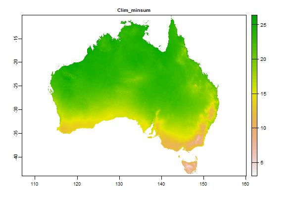
1.2 Gb | Clim_minsum |
Name : Clim_minsum
Description : Average daily min temperature - Summer
Source : BOM
Metadata : https://shiny.esoil.io/Apps/Covariates?Attribute=Climate&Name=Clim_minsum&Resolution=90m
Units : degrees celcius
SCORPAN : Climate
Original Resolution : 5km
|
Average daily min temperature - Summer | MetaData |
 Click to enlarge the image
|
|
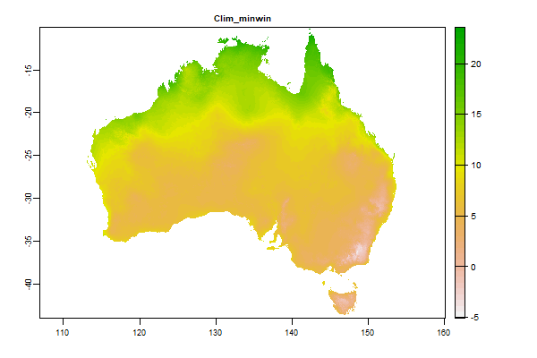
1.3 Gb | Clim_minwin |
Name : Clim_minwin
Description : Average daily max temperature - Winter
Source : BOM
Metadata : https://shiny.esoil.io/Apps/Covariates?Attribute=Climate&Name=Clim_minwin&Resolution=90m
Units : degrees celcius
SCORPAN : Climate
Original Resolution : 5km
|
Average daily max temperature - Winter | MetaData |
 Click to enlarge the image
|
|
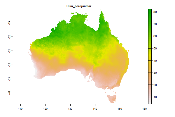
1.3 Gb | Clim_percjanmar |
Name : Clim_percjanmar
Description : Average Rainfall - Wet Season
Source : BOM
Metadata : https://shiny.esoil.io/Apps/Covariates?Attribute=Climate&Name=Clim_percjanmar&Resolution=90m
Units : percent
SCORPAN : Climate
Original Resolution : 5km
|
Average Rainfall - Wet Season | MetaData |
 Click to enlarge the image
|
|
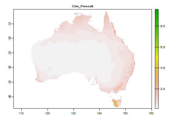
4 Gb | Clim_Prescott |
Name : Clim_Prescott
Description : Prescott Index generated by Ross Searle using PI =0.445P / E0.75
Source : Unknown
Metadata : https://shiny.esoil.io/Apps/Covariates?Attribute=Climate&Name=Clim_Prescott&Resolution=90m
Units : index
SCORPAN : Climate
Original Resolution : 5km
|
Prescott Index generated by Ross Searle using PI =0.445P / E0.75 | MetaData |
 Click to enlarge the image
|
|
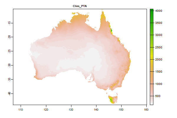
3.2 Gb | Clim_PTA |
Name : Clim_PTA
Description : Annual precipitation (mm)
Source : CSIRO
Metadata : https://shiny.esoil.io/Apps/Covariates?Attribute=Climate&Name=Clim_PTA&Resolution=90m
Units : mm
SCORPAN : Climate
Original Resolution : 90m
|
Annual precipitation (mm) | MetaData |
 Click to enlarge the image
|
|
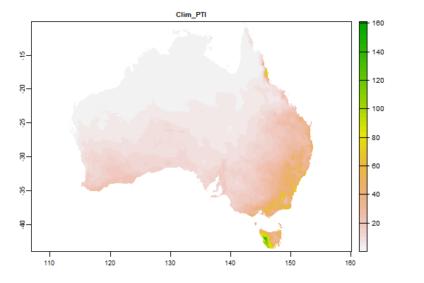
3.6 Gb | Clim_PTI |
Name : Clim_PTI
Description : Minimum monthly precipitation (mm)
Source : CSIRO
Metadata : https://shiny.esoil.io/Apps/Covariates?Attribute=Climate&Name=Clim_PTI&Resolution=90m
Units : mm
SCORPAN : Climate
Original Resolution : 90m
|
Minimum monthly precipitation (mm) | MetaData |
 Click to enlarge the image
|
|
3.2 Gb | Clim_PTRI |
Name : Clim_PTRI
Description : Precipitation seasonality – minimum of differences between successive months
Source : CSIRO
Metadata : https://shiny.esoil.io/Apps/Covariates?Attribute=Climate&Name=Clim_PTRI&Resolution=90m
Units : mm/day
SCORPAN : Climate
Original Resolution : 90m
|
Precipitation seasonality – minimum of differences between successive months | MetaData |
 Click to enlarge the image
|
|
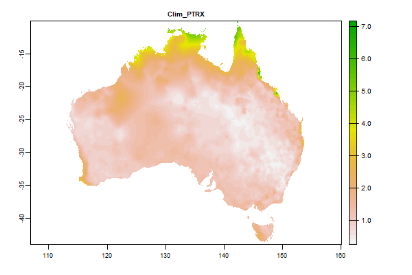
3.2 Gb | Clim_PTRX |
Name : Clim_PTRX
Description : Precipitation seasonality – maximum of differences between successive months
Source : CSIRO
Metadata : https://shiny.esoil.io/Apps/Covariates?Attribute=Climate&Name=Clim_PTRX&Resolution=90m
Units : mm/day
SCORPAN : Climate
Original Resolution : 90m
|
Precipitation seasonality – maximum of differences between successive months | MetaData |
 Click to enlarge the image
|
|
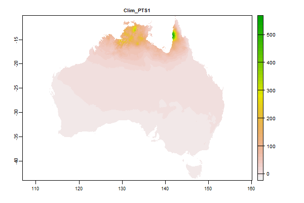
3.5 Gb | Clim_PTS1 |
Name : Clim_PTS1
Description : Precipitation seasonality 1- solstice seasonality composite factor ratio
Source : CSIRO
Metadata : https://shiny.esoil.io/Apps/Covariates?Attribute=Climate&Name=Clim_PTS1&Resolution=90m
Units : ratio
SCORPAN : Climate
Original Resolution : 90m
|
Precipitation seasonality 1- solstice seasonality composite factor ratio | MetaData |
 Click to enlarge the image
|
|
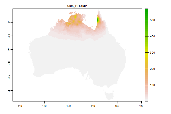
3.4 Gb | Clim_PTS1MP |
Name : Clim_PTS1MP
Description : Precipitation - solstice seasonality ratio alternative
Source : CSIRO
Metadata : https://shiny.esoil.io/Apps/Covariates?Attribute=Climate&Name=Clim_PTS1MP&Resolution=90m
Units : ratio
SCORPAN : Climate
Original Resolution : 90m
|
Precipitation - solstice seasonality ratio alternative | MetaData |
 Click to enlarge the image
|
|
3.3 Gb | Clim_PTS2 |
Name : Clim_PTS2
Description : Precipitation seasonality 2- equinox seasonality composite factor ratio
Source : CSIRO
Metadata : https://shiny.esoil.io/Apps/Covariates?Attribute=Climate&Name=Clim_PTS2&Resolution=90m
Units : ratio
SCORPAN : Climate
Original Resolution : 90m
|
Precipitation seasonality 2- equinox seasonality composite factor ratio | MetaData |
 Click to enlarge the image
|
|
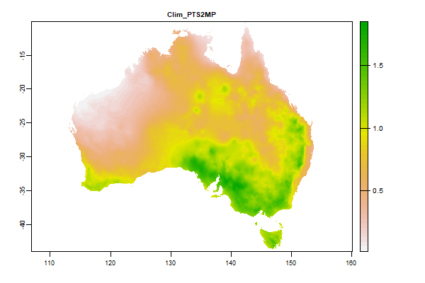
3.2 Gb | Clim_PTS2MP |
Name : Clim_PTS2MP
Description : Precipitation - equinox seasonality ratio alternative
Source : CSIRO
Metadata : https://shiny.esoil.io/Apps/Covariates?Attribute=Climate&Name=Clim_PTS2MP&Resolution=90m
Units : ratio
SCORPAN : Climate
Original Resolution : 90m
|
Precipitation - equinox seasonality ratio alternative | MetaData |
 Click to enlarge the image
|
|
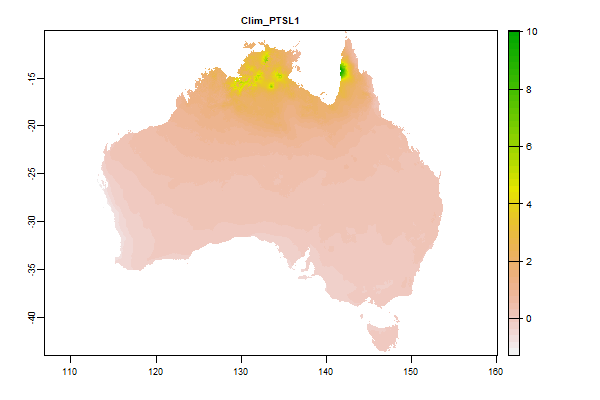
3.1 Gb | Clim_PTSL1 |
Name : Clim_PTSL1
Description : Log Precip Seasonality 1
Source : CSIRO
Metadata : https://shiny.esoil.io/Apps/Covariates?Attribute=Climate&Name=Clim_PTSL1&Resolution=90m
Units : none
SCORPAN : Climate
Original Resolution : 90m
|
Log Precip Seasonality 1 | MetaData |
 Click to enlarge the image
|
|
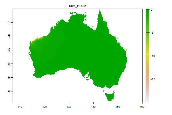
2.8 Gb | Clim_PTSL2 |
Name : Clim_PTSL2
Description : Log Precip Seasonality 2
Source : CSIRO
Metadata : https://shiny.esoil.io/Apps/Covariates?Attribute=Climate&Name=Clim_PTSL2&Resolution=90m
Units : none
SCORPAN : Climate
Original Resolution : 90m
|
Log Precip Seasonality 2 | MetaData |
 Click to enlarge the image
|
|
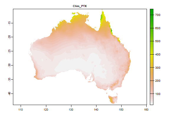
3.2 Gb | Clim_PTX |
Name : Clim_PTX
Description : Maximum monthly precipitation (mm)
Source : CSIRO
Metadata : https://shiny.esoil.io/Apps/Covariates?Attribute=Climate&Name=Clim_PTX&Resolution=90m
Units : mm
SCORPAN : Climate
Original Resolution : 90m
|
Maximum monthly precipitation (mm) | MetaData |
 Click to enlarge the image
|
|
917.1 Mb | Clim_rain1mman |
Name : Clim_rain1mman
Description : Average Number of days with rainfall greater than 1mm Annual
Source : BOM
Metadata : https://shiny.esoil.io/Apps/Covariates?Attribute=Climate&Name=Clim_rain1mman&Resolution=90m
Units : number of days
SCORPAN : Climate
Original Resolution : 5km
|
Average Number of days with rainfall greater than 1mm Annual | MetaData |
 Click to enlarge the image
|
|
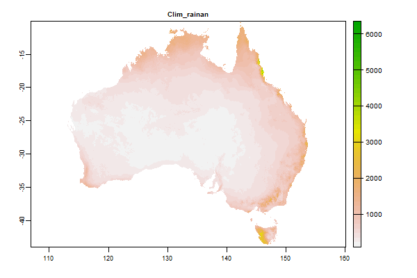
284.4 Mb | Clim_rainan |
Name : Clim_rainan
Description : Average Rainfall - Annual
Source : BOM
Metadata : https://shiny.esoil.io/Apps/Covariates?Attribute=Climate&Name=Clim_rainan&Resolution=90m
Units : mm
SCORPAN : Climate
Original Resolution : 5km
|
Average Rainfall - Annual | MetaData |
 Click to enlarge the image
|
|
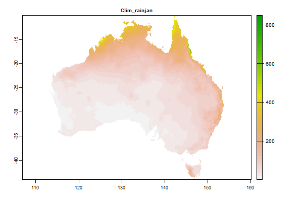
120.1 Mb | Clim_rainjan |
Name : Clim_rainjan
Description : Average Rainfall - January
Source : BOM
Metadata : https://shiny.esoil.io/Apps/Covariates?Attribute=Climate&Name=Clim_rainjan&Resolution=90m
Units : mm
SCORPAN : Climate
Original Resolution : 5km
|
Average Rainfall - January | MetaData |
 Click to enlarge the image
|
|
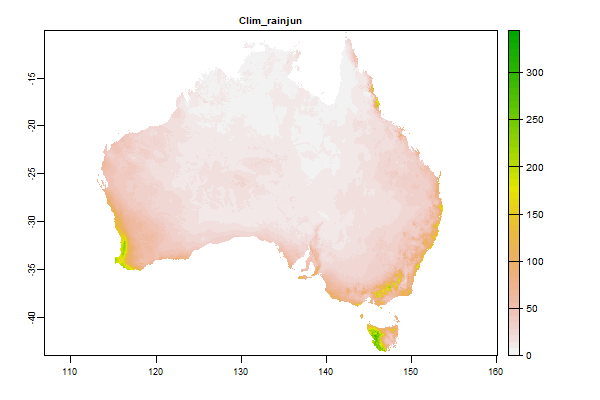
114.7 Mb | Clim_rainjun |
Name : Clim_rainjun
Description : Average Rainfall - June
Source : BOM
Metadata : https://shiny.esoil.io/Apps/Covariates?Attribute=Climate&Name=Clim_rainjun&Resolution=90m
Units : mm
SCORPAN : Climate
Original Resolution : 5km
|
Average Rainfall - June | MetaData |
 Click to enlarge the image
|
|
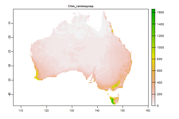
1.5 Gb | Clim_rainmaysep |
Name : Clim_rainmaysep
Description : Average total rainfall for May to September
Source : BOM
Metadata : https://shiny.esoil.io/Apps/Covariates?Attribute=Climate&Name=Clim_rainmaysep&Resolution=90m
Units : mm
SCORPAN : Climate
Original Resolution : 5km
|
Average total rainfall for May to September | MetaData |
 Click to enlarge the image
|
|
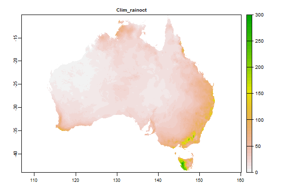
106.9 Mb | Clim_rainoct |
Name : Clim_rainoct
Description : Average Rainfall - October
Source : BOM
Metadata : https://shiny.esoil.io/Apps/Covariates?Attribute=Climate&Name=Clim_rainoct&Resolution=90m
Units : mm
SCORPAN : Climate
Original Resolution : 5km
|
Average Rainfall - October | MetaData |
 Click to enlarge the image
|
|
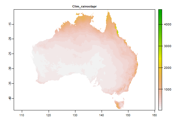
1.4 Gb | Clim_rainoctapr |
Name : Clim_rainoctapr
Description : Average total rainfall for October to April
Source : BOM
Metadata : https://shiny.esoil.io/Apps/Covariates?Attribute=Climate&Name=Clim_rainoctapr&Resolution=90m
Units : mm
SCORPAN : Climate
Original Resolution : 5km
|
Average total rainfall for October to April | MetaData |
 Click to enlarge the image
|
|
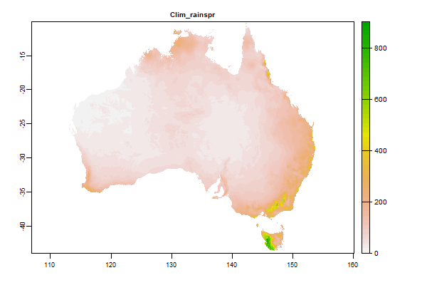
1.5 Gb | Clim_rainspr |
Name : Clim_rainspr
Description : Average Rainfall - Spring
Source : BOM
Metadata : https://shiny.esoil.io/Apps/Covariates?Attribute=Climate&Name=Clim_rainspr&Resolution=90m
Units : mm
SCORPAN : Climate
Original Resolution : 5km
|
Average Rainfall - Spring | MetaData |
 Click to enlarge the image
|
|
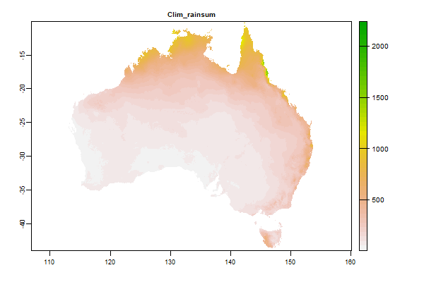
1.4 Gb | Clim_rainsum |
Name : Clim_rainsum
Description : Average Rainfall - Summer
Source : BOM
Metadata : https://shiny.esoil.io/Apps/Covariates?Attribute=Climate&Name=Clim_rainsum&Resolution=90m
Units : mm
SCORPAN : Climate
Original Resolution : 5km
|
Average Rainfall - Summer | MetaData |
 Click to enlarge the image
|
|
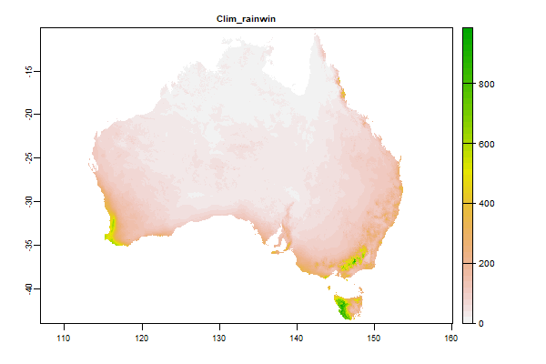
1.6 Gb | Clim_rainwin |
Name : Clim_rainwin
Description : Average Rainfall - Winter
Source : BOM
Metadata : https://shiny.esoil.io/Apps/Covariates?Attribute=Climate&Name=Clim_rainwin&Resolution=90m
Units : mm
SCORPAN : Climate
Original Resolution : 5km
|
Average Rainfall - Winter | MetaData |
 Click to enlarge the image
|
|
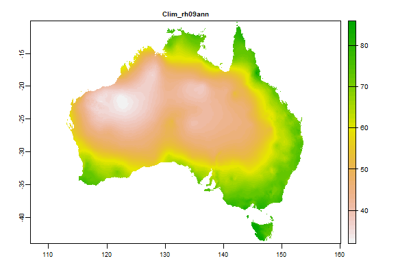
71.2 Mb | Clim_rh09ann |
Name : Clim_rh09ann
Description : Relative Humidity 9am Annual
Source : BOM
Metadata : https://shiny.esoil.io/Apps/Covariates?Attribute=Climate&Name=Clim_rh09ann&Resolution=90m
Units : percent
SCORPAN : Climate
Original Resolution : 5km
|
Relative Humidity 9am Annual | MetaData |
 Click to enlarge the image
|
|
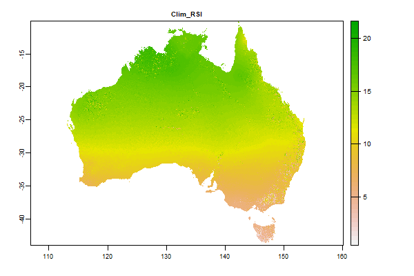
4.2 Gb | Clim_RSI |
Name : Clim_RSI
Description : Short-wave solar radiation - monthly minimum (SRAD data)
Source : CSIRO
Metadata : https://shiny.esoil.io/Apps/Covariates?Attribute=Climate&Name=Clim_RSI&Resolution=90m
Units : MJ/m2/day
SCORPAN : Climate
Original Resolution : 90m
|
Short-wave solar radiation - monthly minimum (SRAD data) | MetaData |
 Click to enlarge the image
|
|
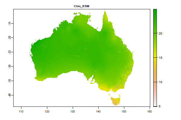
3.9 Gb | Clim_RSM |
Name : Clim_RSM
Description : Short-wave solar radiation - annual mean (SRAD data)
Source : CSIRO
Metadata : https://shiny.esoil.io/Apps/Covariates?Attribute=Climate&Name=Clim_RSM&Resolution=90m
Units : MJ/m2/day
SCORPAN : Climate
Original Resolution : 90m
|
Short-wave solar radiation - annual mean (SRAD data) | MetaData |
 Click to enlarge the image
|
|
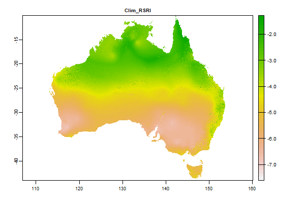
4.1 Gb | Clim_RSRI |
Name : Clim_RSRI
Description : Short-wave solar radiation - min difference between successive months(SRAD data)
Source : CSIRO
Metadata : https://shiny.esoil.io/Apps/Covariates?Attribute=Climate&Name=Clim_RSRI&Resolution=90m
Units : MJ/m2/day
SCORPAN : Climate
Original Resolution : 90m
|
Short-wave solar radiation - min difference between successive months(SRAD data) | MetaData |
 Click to enlarge the image
|
|
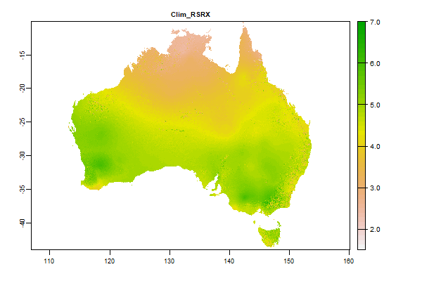
4.1 Gb | Clim_RSRX |
Name : Clim_RSRX
Description : Short-wave solar radiation - max difference between successive months(SRAD data)
Source : CSIRO
Metadata : https://shiny.esoil.io/Apps/Covariates?Attribute=Climate&Name=Clim_RSRX&Resolution=90m
Units : MJ/m2/day
SCORPAN : Climate
Original Resolution : 90m
|
Short-wave solar radiation - max difference between successive months(SRAD data) | MetaData |
 Click to enlarge the image
|
|
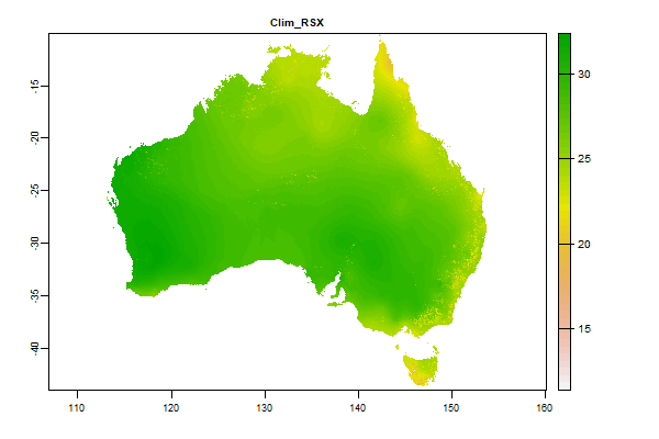
3.5 Gb | Clim_RSX |
Name : Clim_RSX
Description : Short-wave solar radiation - max difference between successive months(SRAD data)
Source : CSIRO
Metadata : https://shiny.esoil.io/Apps/Covariates?Attribute=Climate&Name=Clim_RSX&Resolution=90m
Units : MJ/m2/day
SCORPAN : Climate
Original Resolution : 90m
|
Short-wave solar radiation - max difference between successive months(SRAD data) | MetaData |
 Click to enlarge the image
|
|
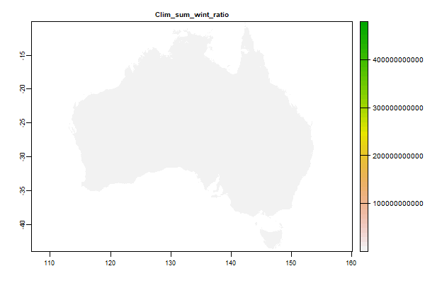
2.4 Gb | Clim_sum_wint_ratio |
Name : Clim_sum_wint_ratio
Description : Average Rainfall - Summer Winter Ratio
Source : Derived from BOM
Metadata : https://shiny.esoil.io/Apps/Covariates?Attribute=Climate&Name=Clim_sum_wint_ratio&Resolution=90m
Units : ratio
SCORPAN : Climate
Original Resolution : 5km
|
Average Rainfall - Summer Winter Ratio | MetaData |
 Click to enlarge the image
|
|
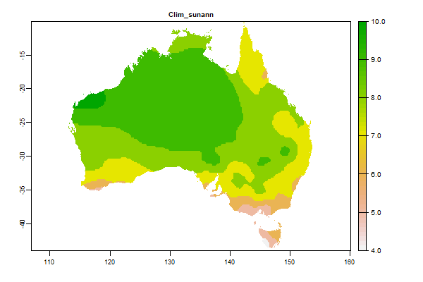
61.9 Mb | Clim_sunann |
Name : Clim_sunann
Description : Average daily sunshine hours - Annual
Source : BOM
Metadata : https://shiny.esoil.io/Apps/Covariates?Attribute=Climate&Name=Clim_sunann&Resolution=90m
Units : hours
SCORPAN : Climate
Original Resolution : 5km
|
Average daily sunshine hours - Annual | MetaData |
 Click to enlarge the image
|
|
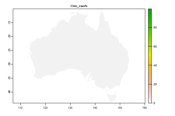
67.5 Mb | Clim_swofs |
Name : Clim_swofs
Description : WaterObservations from Space SALTWATER(Split Fresh/Salt to deal with coastal systems)
Source : CSIRO
Metadata : https://shiny.esoil.io/Apps/Covariates?Attribute=Climate&Name=Clim_swofs&Resolution=90m
Units : percent
SCORPAN : Climate
Original Resolution : 90m
|
WaterObservations from Space SALTWATER(Split Fresh/Salt to deal with coastal systems) | MetaData |
 Click to enlarge the image
|
|
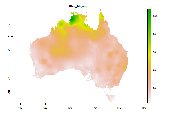
617.3 Mb | Clim_tdayann |
Name : Clim_tdayann
Description : Average thunder days - Annual
Source : BOM
Metadata : https://shiny.esoil.io/Apps/Covariates?Attribute=Climate&Name=Clim_tdayann&Resolution=90m
Units : percent
SCORPAN : Climate
Original Resolution : 5km
|
Average thunder days - Annual | MetaData |
 Click to enlarge the image
|
|
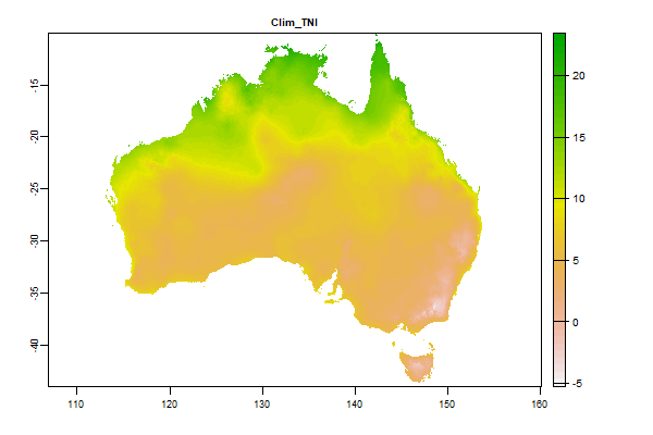
3.1 Gb | Clim_TNI |
Name : Clim_TNI
Description : Minimum temperature - monthly minimum (°C)
Source : CSIRO
Metadata : https://shiny.esoil.io/Apps/Covariates?Attribute=Climate&Name=Clim_TNI&Resolution=90m
Units : degrees celcius
SCORPAN : Climate
Original Resolution : 90m
|
Minimum temperature - monthly minimum (°C) | MetaData |
 Click to enlarge the image
|
|
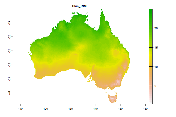
2.9 Gb | Clim_TNM |
Name : Clim_TNM
Description : Minimum temperature – Annual mean (°C)
Source : CSIRO
Metadata : https://shiny.esoil.io/Apps/Covariates?Attribute=Climate&Name=Clim_TNM&Resolution=90m
Units : degrees celcius
SCORPAN : Climate
Original Resolution : 90m
|
Minimum temperature – Annual mean (°C) | MetaData |
 Click to enlarge the image
|
|
2.8 Gb | Clim_TNRI |
Name : Clim_TNRI
Description : Temperature - min difference in min between successive months
Source : CSIRO
Metadata : https://shiny.esoil.io/Apps/Covariates?Attribute=Climate&Name=Clim_TNRI&Resolution=90m
Units : degrees celcius per day
SCORPAN : Climate
Original Resolution : 90m
|
Temperature - min difference in min between successive months | MetaData |
 Click to enlarge the image
|
|
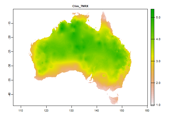
2.9 Gb | Clim_TNRX |
Name : Clim_TNRX
Description : Temperature - max difference in min between successive months
Source : CSIRO
Metadata : https://shiny.esoil.io/Apps/Covariates?Attribute=Climate&Name=Clim_TNRX&Resolution=90m
Units : degrees celcius per day
SCORPAN : Climate
Original Resolution : 90m
|
Temperature - max difference in min between successive months | MetaData |
 Click to enlarge the image
|
|
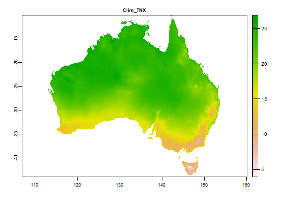
2.8 Gb | Clim_TNX |
Name : Clim_TNX
Description : Minimum temperature - monthly maximum (°C)
Source : CSIRO
Metadata : https://shiny.esoil.io/Apps/Covariates?Attribute=Climate&Name=Clim_TNX&Resolution=90m
Units : degrees celcius
SCORPAN : Climate
Original Resolution : 90m
|
Minimum temperature - monthly maximum (°C) | MetaData |
 Click to enlarge the image
|
|
3.2 Gb | Clim_TRA |
Name : Clim_TRA
Description : Annual temperature range (TXX – TNI) (°C)
Source : CSIRO
Metadata : https://shiny.esoil.io/Apps/Covariates?Attribute=Climate&Name=Clim_TRA&Resolution=90m
Units : degrees celcius
SCORPAN : Climate
Original Resolution : 90m
|
Annual temperature range (TXX – TNI) (°C) | MetaData |
 Click to enlarge the image
|
|
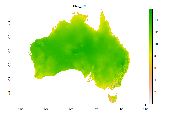
3.6 Gb | Clim_TRI |
Name : Clim_TRI
Description : Minimum monthly mean diurnal temperature range (°C)
Source : CSIRO
Metadata : https://shiny.esoil.io/Apps/Covariates?Attribute=Climate&Name=Clim_TRI&Resolution=90m
Units : degrees celcius
SCORPAN : Climate
Original Resolution : 90m
|
Minimum monthly mean diurnal temperature range (°C) | MetaData |
 Click to enlarge the image
|
|
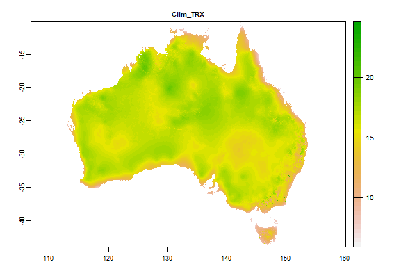
3.4 Gb | Clim_TRX |
Name : Clim_TRX
Description : Maximum monthly mean diurnal temperature range (°C)
Source : CSIRO
Metadata : https://shiny.esoil.io/Apps/Covariates?Attribute=Climate&Name=Clim_TRX&Resolution=90m
Units : degrees celcius
SCORPAN : Climate
Original Resolution : 90m
|
Maximum monthly mean diurnal temperature range (°C) | MetaData |
 Click to enlarge the image
|
|
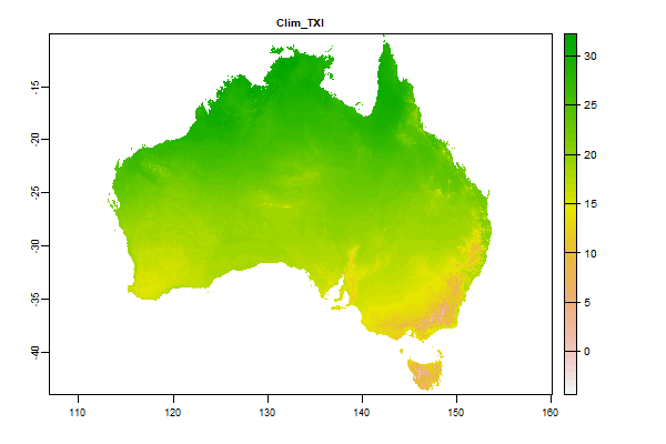
3.9 Gb | Clim_TXI |
Name : Clim_TXI
Description : Maximum temperature - monthly minimum (°C)
Source : CSIRO
Metadata : https://shiny.esoil.io/Apps/Covariates?Attribute=Climate&Name=Clim_TXI&Resolution=90m
Units : degrees celcius
SCORPAN : Climate
Original Resolution : 90m
|
Maximum temperature - monthly minimum (°C) | MetaData |
 Click to enlarge the image
|
|
3.6 Gb | Clim_TXM |
Name : Clim_TXM
Description : NA
Source : CSIRO
Metadata : https://shiny.esoil.io/Apps/Covariates?Attribute=Climate&Name=Clim_TXM&Resolution=90m
Units : NA
SCORPAN : Climate
Original Resolution : 90m
|
NA | MetaData |
 Click to enlarge the image
|
|
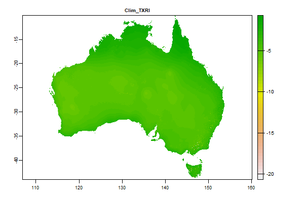
3.9 Gb | Clim_TXRI |
Name : Clim_TXRI
Description : Temperature - min difference in max between successive months
Source : CSIRO
Metadata : https://shiny.esoil.io/Apps/Covariates?Attribute=Climate&Name=Clim_TXRI&Resolution=90m
Units : degrees celcius per day
SCORPAN : Climate
Original Resolution : 90m
|
Temperature - min difference in max between successive months | MetaData |
 Click to enlarge the image
|
|
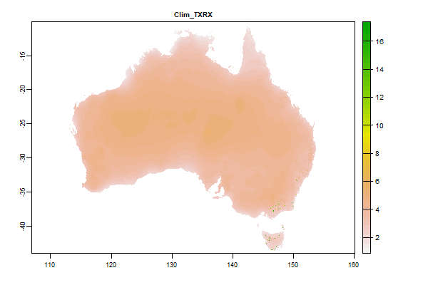
3.9 Gb | Clim_TXRX |
Name : Clim_TXRX
Description : Temperature - max difference in max between successive months
Source : CSIRO
Metadata : https://shiny.esoil.io/Apps/Covariates?Attribute=Climate&Name=Clim_TXRX&Resolution=90m
Units : degrees celcius per day
SCORPAN : Climate
Original Resolution : 90m
|
Temperature - max difference in max between successive months | MetaData |
 Click to enlarge the image
|
|
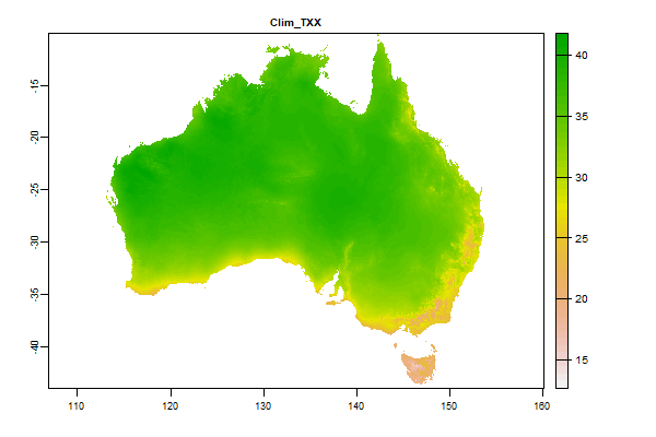
3.2 Gb | Clim_TXX |
Name : Clim_TXX
Description : Maximum temperature - monthly maximum (°C)
Source : CSIRO
Metadata : https://shiny.esoil.io/Apps/Covariates?Attribute=Climate&Name=Clim_TXX&Resolution=90m
Units : degrees celcius
SCORPAN : Climate
Original Resolution : 90m
|
Maximum temperature - monthly maximum (°C) | MetaData |
 Click to enlarge the image
|
|
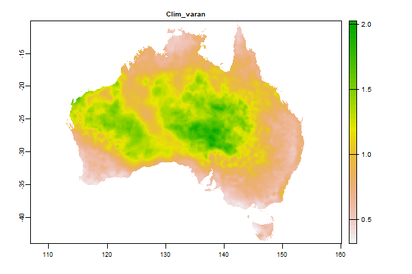
697 Mb | Clim_varan |
Name : Clim_varan
Description : Rainfall Variability - Annual
Source : BOM
Metadata : https://shiny.esoil.io/Apps/Covariates?Attribute=Climate&Name=Clim_varan&Resolution=90m
Units : ratio
SCORPAN : Climate
Original Resolution : 5km
|
Rainfall Variability - Annual | MetaData |
 Click to enlarge the image
|
|
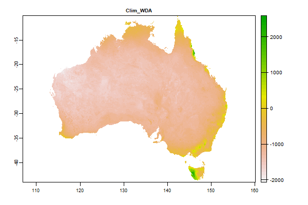
3.9 Gb | Clim_WDA |
Name : Clim_WDA
Description : Annual atmospheric water deficit (annual precipitation – annual potential evaporation) (mm)
Source : CSIRO
Metadata : https://shiny.esoil.io/Apps/Covariates?Attribute=Climate&Name=Clim_WDA&Resolution=90m
Units : mm
SCORPAN : Climate
Original Resolution : 90m
|
Annual atmospheric water deficit (annual precipitation – annual potential evaporation) (mm) | MetaData |
 Click to enlarge the image
|
|
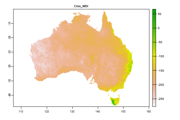
3.7 Gb | Clim_WDI |
Name : Clim_WDI
Description : Minimum monthly atmospheric water deficit (precipitation - potential evaporation) (mm)
Source : CSIRO
Metadata : https://shiny.esoil.io/Apps/Covariates?Attribute=Climate&Name=Clim_WDI&Resolution=90m
Units : mm
SCORPAN : Climate
Original Resolution : 90m
|
Minimum monthly atmospheric water deficit (precipitation - potential evaporation) (mm) | MetaData |
 Click to enlarge the image
|
|
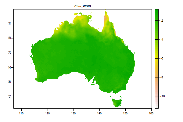
3.8 Gb | Clim_WDRI |
Name : Clim_WDRI
Description : Atmospheric water deficit seasonality – minimum of differences between successive months
Source : CSIRO
Metadata : https://shiny.esoil.io/Apps/Covariates?Attribute=Climate&Name=Clim_WDRI&Resolution=90m
Units : mm
SCORPAN : Climate
Original Resolution : 90m
|
Atmospheric water deficit seasonality – minimum of differences between successive months | MetaData |
 Click to enlarge the image
|
|
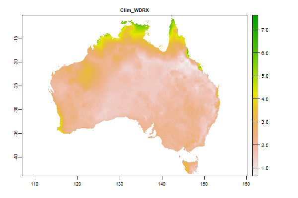
3.8 Gb | Clim_WDRX |
Name : Clim_WDRX
Description : Atmospheric water deficit seasonality – maximum of differences between successive months
Source : CSIRO
Metadata : https://shiny.esoil.io/Apps/Covariates?Attribute=Climate&Name=Clim_WDRX&Resolution=90m
Units : mm/day
SCORPAN : Climate
Original Resolution : 90m
|
Atmospheric water deficit seasonality – maximum of differences between successive months | MetaData |
 Click to enlarge the image
|
|
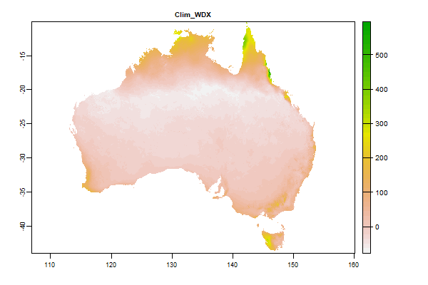
4.1 Gb | Clim_WDX |
Name : Clim_WDX
Description : Maximum monthly atmospheric water deficit (precipitation - potential evaporation) (mm)
Source : CSIRO
Metadata : https://shiny.esoil.io/Apps/Covariates?Attribute=Climate&Name=Clim_WDX&Resolution=90m
Units : mm/day
SCORPAN : Climate
Original Resolution : 90m
|
Maximum monthly atmospheric water deficit (precipitation - potential evaporation) (mm) | MetaData |
 Click to enlarge the image
|
|
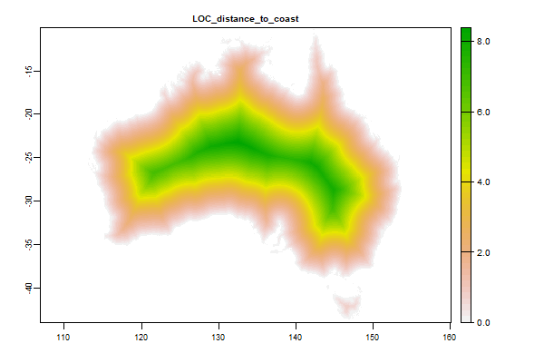
1.4 Gb | LOC_distance_to_coast |
Name : LOC_distance_to_coast
Description : Eucludian distance from the coastline
Source : CSIRO
Metadata : https://shiny.esoil.io/Apps/Covariates?Attribute=Location&Name=LOC_distance_to_coast&Resolution=90m
Units : Degrees
SCORPAN : Location
Original Resolution : 90m
|
Eucludian distance from the coastline | MetaData |
 Click to enlarge the image
|
|
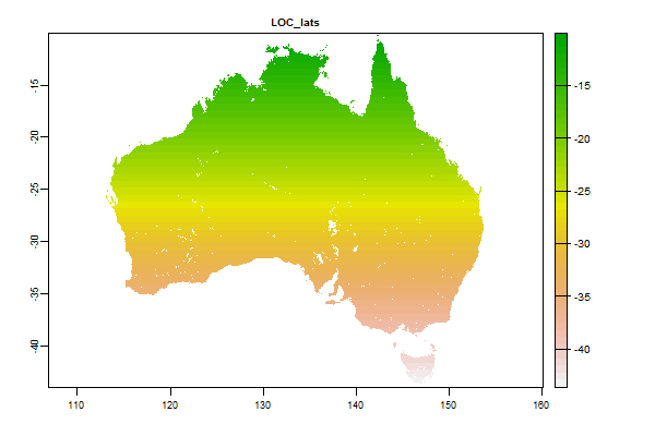
69.1 Mb | LOC_lats |
Name : LOC_lats
Description : Latitudes
Source : CSIRO
Metadata : https://shiny.esoil.io/Apps/Covariates?Attribute=Location&Name=LOC_lats&Resolution=90m
Units : Degrees
SCORPAN : Location
Original Resolution : 90m
|
Latitudes | MetaData |
 Click to enlarge the image
|
|
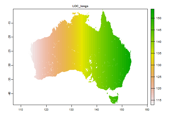
173.3 Mb | LOC_longs |
Name : LOC_longs
Description : Longitudes
Source : CSIRO
Metadata : https://shiny.esoil.io/Apps/Covariates?Attribute=Location&Name=LOC_longs&Resolution=90m
Units : Degrees
SCORPAN : Location
Original Resolution : 90m
|
Longitudes | MetaData |
 Click to enlarge the image
|
|
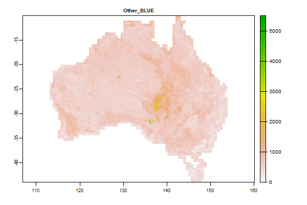
2 Gb | Other_BLUE |
Name : Other_BLUE
Description : Barest Earth Landsat Imagery - BLUE
Source : Geoscience Australia
Metadata : https://shiny.esoil.io/Apps/Covariates?Attribute=Other&Name=Other_BLUE&Resolution=90m
Units : none
SCORPAN : Other
Original Resolution : 25m
|
Barest Earth Landsat Imagery - BLUE | MetaData |
 Click to enlarge the image
|
|
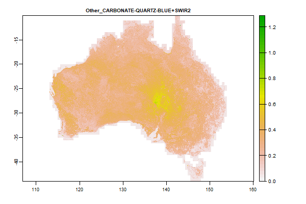
5.4 Gb | Other_CARBONATE-QUARTZ-BLUE+SWIR2 |
Name : Other_CARBONATE-QUARTZ-BLUE+SWIR2
Description : Barest Earth Landsat Imagery - CARBONATE-QUARTZ-BLUE+SWIR2
Source : Geoscience Australia
Metadata : https://shiny.esoil.io/Apps/Covariates?Attribute=Other&Name=Other_CARBONATE-QUARTZ-BLUE+SWIR2&Resolution=90m
Units : none
SCORPAN : Other
Original Resolution : 25m
|
Barest Earth Landsat Imagery - CARBONATE-QUARTZ-BLUE+SWIR2 | MetaData |
 Click to enlarge the image
|
|
5.7 Gb | Other_FERRIC-PC2 |
Name : Other_FERRIC-PC2
Description : Barest Earth Landsat Imagery - FERRIC-PC2
Source : Geoscience Australia
Metadata : https://shiny.esoil.io/Apps/Covariates?Attribute=Other&Name=Other_FERRIC-PC2&Resolution=90m
Units : none
SCORPAN : Other
Original Resolution : 25m
|
Barest Earth Landsat Imagery - FERRIC-PC2 | MetaData |
 Click to enlarge the image
|
|
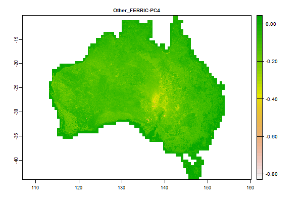
5.8 Gb | Other_FERRIC-PC4 |
Name : Other_FERRIC-PC4
Description : Barest Earth Landsat Imagery - FERRIC-PC4
Source : Geoscience Australia
Metadata : https://shiny.esoil.io/Apps/Covariates?Attribute=Other&Name=Other_FERRIC-PC4&Resolution=90m
Units : none
SCORPAN : Other
Original Resolution : 25m
|
Barest Earth Landsat Imagery - FERRIC-PC4 | MetaData |
 Click to enlarge the image
|
|
4.4 Gb | Other_gg_clip |
Name : Other_gg_clip
Description : NA
Source : CSIRO
Metadata : https://shiny.esoil.io/Apps/Covariates?Attribute=Other&Name=Other_gg_clip&Resolution=90m
Units : NA
SCORPAN : Other
Original Resolution : 3 arc-second
|
NA | MetaData |
 Click to enlarge the image
|
|
2.2 Gb | Other_GREEN |
Name : Other_GREEN
Description : Barest Earth Landsat Imagery - GREEN
Source : Geoscience Australia
Metadata : https://shiny.esoil.io/Apps/Covariates?Attribute=Other&Name=Other_GREEN&Resolution=90m
Units : none
SCORPAN : Other
Original Resolution : 25m
|
Barest Earth Landsat Imagery - GREEN | MetaData |
 Click to enlarge the image
|
|
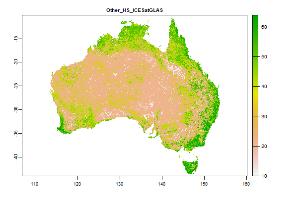
313.8 Mb | Other_HS_ICESatGLAS |
Name : Other_HS_ICESatGLAS
Description : Barest Earth Landsat Imagery - HS_ICESatGLAS
Source : Geoscience Australia
Metadata : https://shiny.esoil.io/Apps/Covariates?Attribute=Other&Name=Other_HS_ICESatGLAS&Resolution=90m
Units : none
SCORPAN : Other
Original Resolution : 25m
|
Barest Earth Landsat Imagery - HS_ICESatGLAS | MetaData |
 Click to enlarge the image
|
|
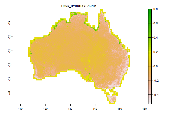
5.8 Gb | Other_HYDROXYL-1-PC1 |
Name : Other_HYDROXYL-1-PC1
Description : Barest Earth Landsat Imagery - HYDROXYL-1-PC1
Source : Geoscience Australia
Metadata : https://shiny.esoil.io/Apps/Covariates?Attribute=Other&Name=Other_HYDROXYL-1-PC1&Resolution=90m
Units : none
SCORPAN : Other
Original Resolution : 25m
|
Barest Earth Landsat Imagery - HYDROXYL-1-PC1 | MetaData |
 Click to enlarge the image
|
|
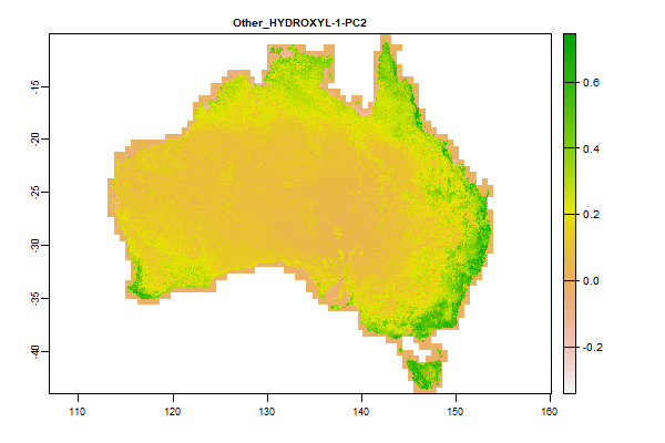
5.9 Gb | Other_HYDROXYL-1-PC2 |
Name : Other_HYDROXYL-1-PC2
Description : Barest Earth Landsat Imagery - HYDROXYL-1-PC2
Source : Geoscience Australia
Metadata : https://shiny.esoil.io/Apps/Covariates?Attribute=Other&Name=Other_HYDROXYL-1-PC2&Resolution=90m
Units : none
SCORPAN : Other
Original Resolution : 25m
|
Barest Earth Landsat Imagery - HYDROXYL-1-PC2 | MetaData |
 Click to enlarge the image
|
|
5.6 Gb | Other_HYDROXYL-2-PC2 |
Name : Other_HYDROXYL-2-PC2
Description : Barest Earth Landsat Imagery - HYDROXYL-2-PC2
Source : Geoscience Australia
Metadata : https://shiny.esoil.io/Apps/Covariates?Attribute=Other&Name=Other_HYDROXYL-2-PC2&Resolution=90m
Units : none
SCORPAN : Other
Original Resolution : 25m
|
Barest Earth Landsat Imagery - HYDROXYL-2-PC2 | MetaData |
 Click to enlarge the image
|
|
5.8 Gb | Other_HYDROXYL-3-PC3 |
Name : Other_HYDROXYL-3-PC3
Description : Barest Earth Landsat Imagery - HYDROXYL-3-PC3
Source : Geoscience Australia
Metadata : https://shiny.esoil.io/Apps/Covariates?Attribute=Other&Name=Other_HYDROXYL-3-PC3&Resolution=90m
Units : none
SCORPAN : Other
Original Resolution : 25m
|
Barest Earth Landsat Imagery - HYDROXYL-3-PC3 | MetaData |
 Click to enlarge the image
|
|
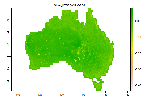
6.1 Gb | Other_HYDROXYL-3-PC4 |
Name : Other_HYDROXYL-3-PC4
Description : Barest Earth Landsat Imagery - HYDROXYL-3-PC4
Source : Geoscience Australia
Metadata : https://shiny.esoil.io/Apps/Covariates?Attribute=Other&Name=Other_HYDROXYL-3-PC4&Resolution=90m
Units : none
SCORPAN : Other
Original Resolution : 25m
|
Barest Earth Landsat Imagery - HYDROXYL-3-PC4 | MetaData |
 Click to enlarge the image
|
|
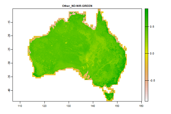
5.4 Gb | Other_ND-NIR-GREEN |
Name : Other_ND-NIR-GREEN
Description : Barest Earth Landsat Imagery - ND-NIR-GREEN
Source : Geoscience Australia
Metadata : https://shiny.esoil.io/Apps/Covariates?Attribute=Other&Name=Other_ND-NIR-GREEN&Resolution=90m
Units : none
SCORPAN : Other
Original Resolution : 25m
|
Barest Earth Landsat Imagery - ND-NIR-GREEN | MetaData |
 Click to enlarge the image
|
|
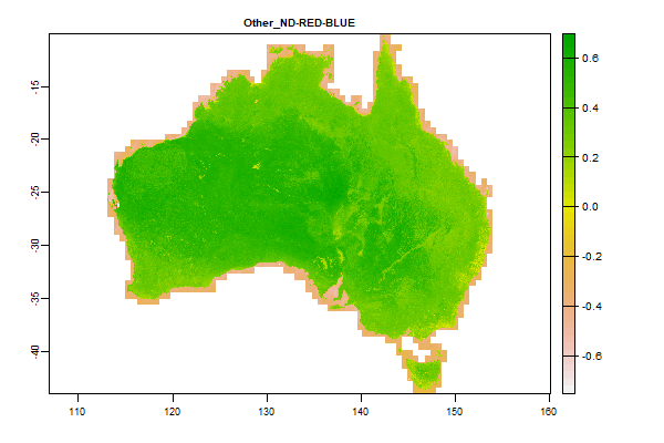
5.4 Gb | Other_ND-RED-BLUE |
Name : Other_ND-RED-BLUE
Description : Barest Earth Landsat Imagery - ND-RED-BLUE
Source : Geoscience Australia
Metadata : https://shiny.esoil.io/Apps/Covariates?Attribute=Other&Name=Other_ND-RED-BLUE&Resolution=90m
Units : none
SCORPAN : Other
Original Resolution : 25m
|
Barest Earth Landsat Imagery - ND-RED-BLUE | MetaData |
 Click to enlarge the image
|
|
5.6 Gb | Other_ND-RED-GREEN |
Name : Other_ND-RED-GREEN
Description : Barest Earth Landsat Imagery - ND-RED-GREEN
Source : Geoscience Australia
Metadata : https://shiny.esoil.io/Apps/Covariates?Attribute=Other&Name=Other_ND-RED-GREEN&Resolution=90m
Units : none
SCORPAN : Other
Original Resolution : 25m
|
Barest Earth Landsat Imagery - ND-RED-GREEN | MetaData |
 Click to enlarge the image
|
|
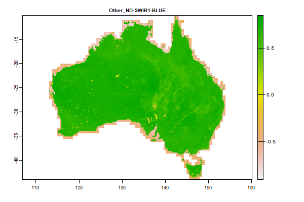
5.1 Gb | Other_ND-SWIR1-BLUE |
Name : Other_ND-SWIR1-BLUE
Description : Barest Earth Landsat Imagery - ND-SWIR1-BLUE
Source : Geoscience Australia
Metadata : https://shiny.esoil.io/Apps/Covariates?Attribute=Other&Name=Other_ND-SWIR1-BLUE&Resolution=90m
Units : none
SCORPAN : Other
Original Resolution : 25m
|
Barest Earth Landsat Imagery - ND-SWIR1-BLUE | MetaData |
 Click to enlarge the image
|
|
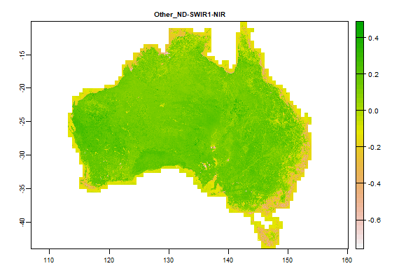
5.9 Gb | Other_ND-SWIR1-NIR |
Name : Other_ND-SWIR1-NIR
Description : Barest Earth Landsat Imagery - ND-SWIR1-NIR
Source : Geoscience Australia
Metadata : https://shiny.esoil.io/Apps/Covariates?Attribute=Other&Name=Other_ND-SWIR1-NIR&Resolution=90m
Units : none
SCORPAN : Other
Original Resolution : 25m
|
Barest Earth Landsat Imagery - ND-SWIR1-NIR | MetaData |
 Click to enlarge the image
|
|
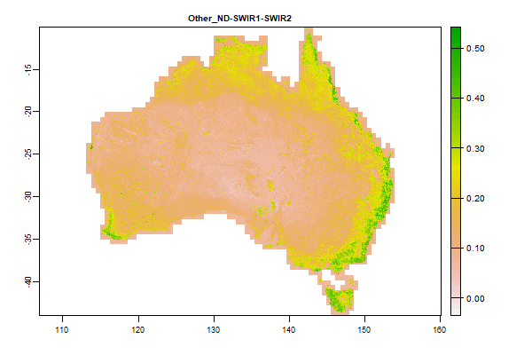
5.7 Gb | Other_ND-SWIR1-SWIR2 |
Name : Other_ND-SWIR1-SWIR2
Description : Barest Earth Landsat Imagery - ND-SWIR1-SWIR2
Source : Geoscience Australia
Metadata : https://shiny.esoil.io/Apps/Covariates?Attribute=Other&Name=Other_ND-SWIR1-SWIR2&Resolution=90m
Units : none
SCORPAN : Other
Original Resolution : 25m
|
Barest Earth Landsat Imagery - ND-SWIR1-SWIR2 | MetaData |
 Click to enlarge the image
|
|
5.5 Gb | Other_ND-SWIR2-GREEN |
Name : Other_ND-SWIR2-GREEN
Description : Barest Earth Landsat Imagery - ND-SWIR2-GREEN
Source : Geoscience Australia
Metadata : https://shiny.esoil.io/Apps/Covariates?Attribute=Other&Name=Other_ND-SWIR2-GREEN&Resolution=90m
Units : none
SCORPAN : Other
Original Resolution : 25m
|
Barest Earth Landsat Imagery - ND-SWIR2-GREEN | MetaData |
 Click to enlarge the image
|
|
6.1 Gb | Other_ND-SWIR2-NIR |
Name : Other_ND-SWIR2-NIR
Description : Barest Earth Landsat Imagery - ND-SWIR2-NIR
Source : Geoscience Australia
Metadata : https://shiny.esoil.io/Apps/Covariates?Attribute=Other&Name=Other_ND-SWIR2-NIR&Resolution=90m
Units : none
SCORPAN : Other
Original Resolution : 25m
|
Barest Earth Landsat Imagery - ND-SWIR2-NIR | MetaData |
 Click to enlarge the image
|
|
5.4 Gb | Other_ND-SWIR2-RED |
Name : Other_ND-SWIR2-RED
Description : Barest Earth Landsat Imagery - ND-SWIR2-RED
Source : Geoscience Australia
Metadata : https://shiny.esoil.io/Apps/Covariates?Attribute=Other&Name=Other_ND-SWIR2-RED&Resolution=90m
Units : none
SCORPAN : Other
Original Resolution : 25m
|
Barest Earth Landsat Imagery - ND-SWIR2-RED | MetaData |
 Click to enlarge the image
|
|
2.5 Gb | Other_NIR |
Name : Other_NIR
Description : Barest Earth Landsat Imagery - NIR
Source : Geoscience Australia
Metadata : https://shiny.esoil.io/Apps/Covariates?Attribute=Other&Name=Other_NIR&Resolution=90m
Units : none
SCORPAN : Other
Original Resolution : 25m
|
Barest Earth Landsat Imagery - NIR | MetaData |
 Click to enlarge the image
|
|
2.4 Gb | Other_RED |
Name : Other_RED
Description : Barest Earth Landsat Imagery - RED
Source : Geoscience Australia
Metadata : https://shiny.esoil.io/Apps/Covariates?Attribute=Other&Name=Other_RED&Resolution=90m
Units : none
SCORPAN : Other
Original Resolution : 25m
|
Barest Earth Landsat Imagery - RED | MetaData |
 Click to enlarge the image
|
|
2.6 Gb | Other_SWIR1 |
Name : Other_SWIR1
Description : Barest Earth Landsat Imagery - SWIR1
Source : Geoscience Australia
Metadata : https://shiny.esoil.io/Apps/Covariates?Attribute=Other&Name=Other_SWIR1&Resolution=90m
Units : none
SCORPAN : Other
Original Resolution : 25m
|
Barest Earth Landsat Imagery - SWIR1 | MetaData |
 Click to enlarge the image
|
|
2.6 Gb | Other_SWIR2 |
Name : Other_SWIR2
Description : Barest Earth Landsat Imagery - SWIR2
Source : Geoscience Australia
Metadata : https://shiny.esoil.io/Apps/Covariates?Attribute=Other&Name=Other_SWIR2&Resolution=90m
Units : none
SCORPAN : Other
Original Resolution : 25m
|
Barest Earth Landsat Imagery - SWIR2 | MetaData |
 Click to enlarge the image
|
|
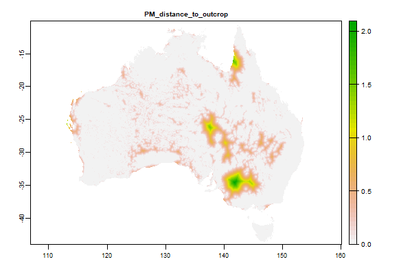
2.3 Gb | PM_distance_to_outcrop |
Name : PM_distance_to_outcrop
Description : Distance from the nearest rock outcrop
Source : Geoscience Australia
Metadata : https://shiny.esoil.io/Apps/Covariates?Attribute=Parent_Material&Name=PM_distance_to_outcrop&Resolution=90m
Units : NA
SCORPAN : Parent_Material
Original Resolution : 3 arc-second
|
Distance from the nearest rock outcrop | MetaData |
 Click to enlarge the image
|
|
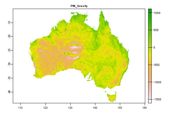
981.9 Mb | PM_Gravity |
Name : PM_Gravity
Description : Fifth Edition Total Magnetic Intensity (TMI) Anomaly Grid of Australia
Source : Geoscience Australia
Metadata : https://shiny.esoil.io/Apps/Covariates?Attribute=Parent_Material&Name=PM_Gravity&Resolution=90m
Units : none
SCORPAN : Parent_Material
Original Resolution : Unkown
|
Fifth Edition Total Magnetic Intensity (TMI) Anomaly Grid of Australia | MetaData |
 Click to enlarge the image
|
|
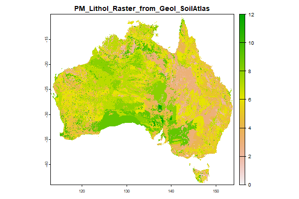
43.9 Mb | PM_Lithol_Raster_from_Geol_SoilAtlas |
Name : PM_Lithol_Raster_from_Geol_SoilAtlas
Description : A simplified surface lithology class map for Australia
Source : Jon Gray
Metadata : https://shiny.esoil.io/Apps/Covariates?Attribute=Parent_Material&Name=PM_Lithol_Raster_from_Geol_SoilAtlas&Resolution=90m
Units : none
SCORPAN : Parent_Material
Original Resolution : 90m
|
A simplified surface lithology class map for Australia | MetaData |
 Click to enlarge the image
|
|
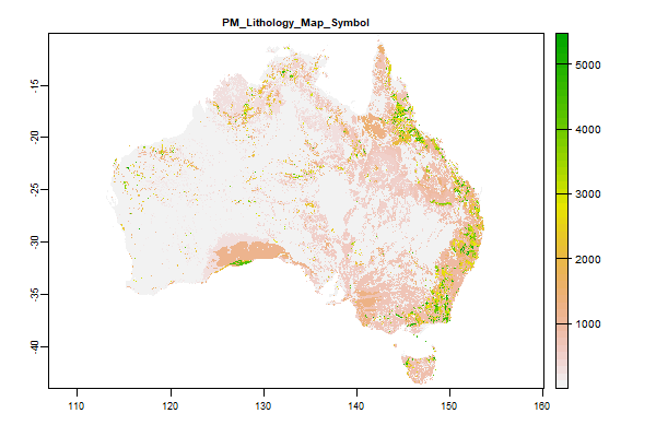
104.3 Mb | PM_Lithology_Map_Symbol |
Name : PM_Lithology_Map_Symbol
Description : Surface Geology of Australia 1:1 million scale dataset 2012 edition - Geologic Unit
Source : Geoscience Australia
Metadata : https://shiny.esoil.io/Apps/Covariates?Attribute=Parent_Material&Name=PM_Lithology_Map_Symbol&Resolution=90m
Units : none
SCORPAN : Parent_Material
Original Resolution : NA
|
Surface Geology of Australia 1:1 million scale dataset 2012 edition - Geologic Unit | MetaData |
 Click to enlarge the image
|
|
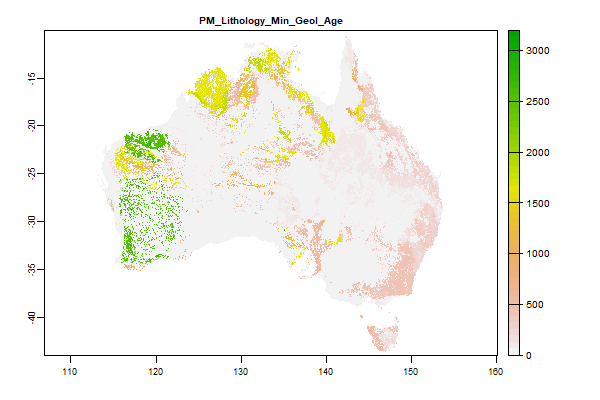
153.3 Mb | PM_Lithology_Min_Geol_Age |
Name : PM_Lithology_Min_Geol_Age
Description : Surface Geology of Australia 1:1 million scale dataset 2012 edition - Minimum Geologic Age
Source : Geoscience Australia
Metadata : https://shiny.esoil.io/Apps/Covariates?Attribute=Parent_Material&Name=PM_Lithology_Min_Geol_Age&Resolution=90m
Units : none
SCORPAN : Parent_Material
Original Resolution : NA
|
Surface Geology of Australia 1:1 million scale dataset 2012 edition - Minimum Geologic Age | MetaData |
 Click to enlarge the image
|
|
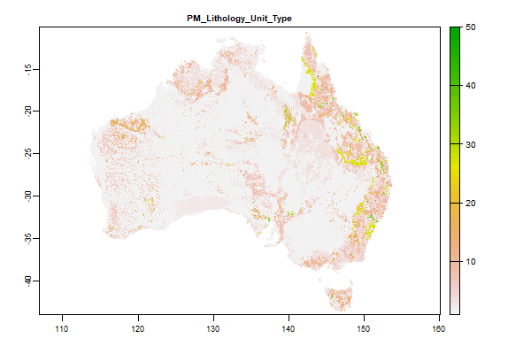
51.4 Mb | PM_Lithology_Unit_Type |
Name : PM_Lithology_Unit_Type
Description : Surface Geology of Australia 1:1 million scale dataset 2012 edition - Lithology Type
Source : Geoscience Australia
Metadata : https://shiny.esoil.io/Apps/Covariates?Attribute=Parent_Material&Name=PM_Lithology_Unit_Type&Resolution=90m
Units : none
SCORPAN : Parent_Material
Original Resolution : NA
|
Surface Geology of Australia 1:1 million scale dataset 2012 edition - Lithology Type | MetaData |
 Click to enlarge the image
|
|
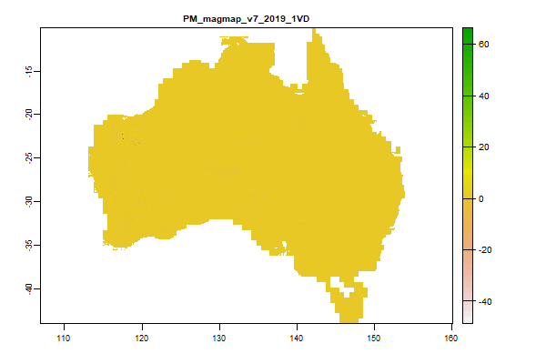
6 Gb | PM_magmap_v7_2019_1VD |
Name : PM_magmap_v7_2019_1VD
Description : Total Magnetic Intensity (TMI) grid of Magnetic Map of Australia. 3rd Edition, 1999 survey - 1VD
Source : Geoscience Australia
Metadata : https://shiny.esoil.io/Apps/Covariates?Attribute=Parent_Material&Name=PM_magmap_v7_2019_1VD&Resolution=90m
Units : none
SCORPAN : Parent_Material
Original Resolution : 0.004 Degrees
|
Total Magnetic Intensity (TMI) grid of Magnetic Map of Australia. 3rd Edition, 1999 survey - 1VD | MetaData |
 Click to enlarge the image
|
|
5 Gb | PM_magmap_v7_2019_RTP |
Name : PM_magmap_v7_2019_RTP
Description : Total Magnetic Intensity (TMI) grid of Magnetic Map of Australia. 3rd Edition, 1999 survey - RTP
Source : Geoscience Australia
Metadata : https://shiny.esoil.io/Apps/Covariates?Attribute=Parent_Material&Name=PM_magmap_v7_2019_RTP&Resolution=90m
Units : none
SCORPAN : Parent_Material
Original Resolution : 0.004 Degrees
|
Total Magnetic Intensity (TMI) grid of Magnetic Map of Australia. 3rd Edition, 1999 survey - RTP | MetaData |
 Click to enlarge the image
|
|
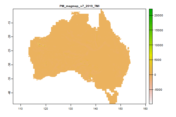
4.9 Gb | PM_magmap_v7_2019_TMI |
Name : PM_magmap_v7_2019_TMI
Description : Total Magnetic Intensity (TMI) grid of Magnetic Map of Australia. 3rd Edition, 1999 survey - TMI
Source : Geoscience Australia
Metadata : https://shiny.esoil.io/Apps/Covariates?Attribute=Parent_Material&Name=PM_magmap_v7_2019_TMI&Resolution=90m
Units : none
SCORPAN : Parent_Material
Original Resolution : 0.004 Degrees
|
Total Magnetic Intensity (TMI) grid of Magnetic Map of Australia. 3rd Edition, 1999 survey - TMI | MetaData |
 Click to enlarge the image
|
|
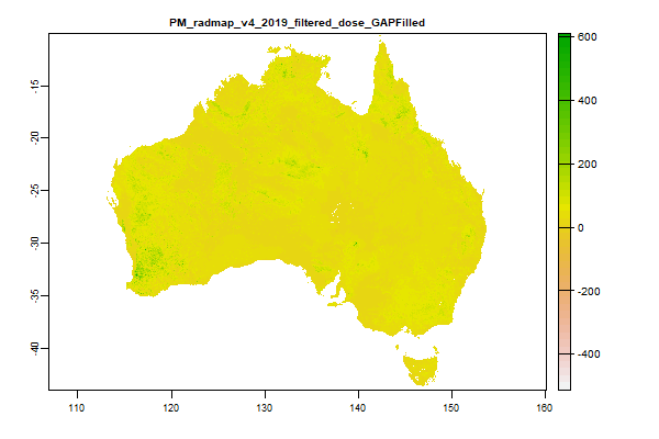
4.3 Gb | PM_radmap_v4_2019_filtered_dose_GAPFilled |
Name : PM_radmap_v4_2019_filtered_dose_GAPFilled
Description : Radiometric grid of Australia (Radmap) v4 2019 - Filtered dose
Source : Geoscience Australia
Metadata : https://shiny.esoil.io/Apps/Covariates?Attribute=Parent_Material&Name=PM_radmap_v4_2019_filtered_dose_GAPFilled&Resolution=90m
Units : none
SCORPAN : Parent_Material
Original Resolution : 0.001 Degrees
|
Radiometric grid of Australia (Radmap) v4 2019 - Filtered dose | MetaData |
 Click to enlarge the image
|
|
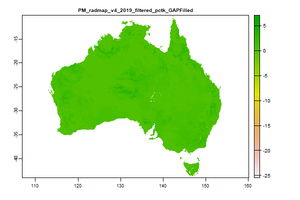
4.5 Gb | PM_radmap_v4_2019_filtered_pctk_GAPFilled |
Name : PM_radmap_v4_2019_filtered_pctk_GAPFilled
Description : Radiometric grid of Australia (Radmap) v4 2019 - Potassium
Source : Geoscience Australia
Metadata : https://shiny.esoil.io/Apps/Covariates?Attribute=Parent_Material&Name=PM_radmap_v4_2019_filtered_pctk_GAPFilled&Resolution=90m
Units : percent
SCORPAN : Parent_Material
Original Resolution : 0.001 Degrees
|
Radiometric grid of Australia (Radmap) v4 2019 - Potassium | MetaData |
 Click to enlarge the image
|
|
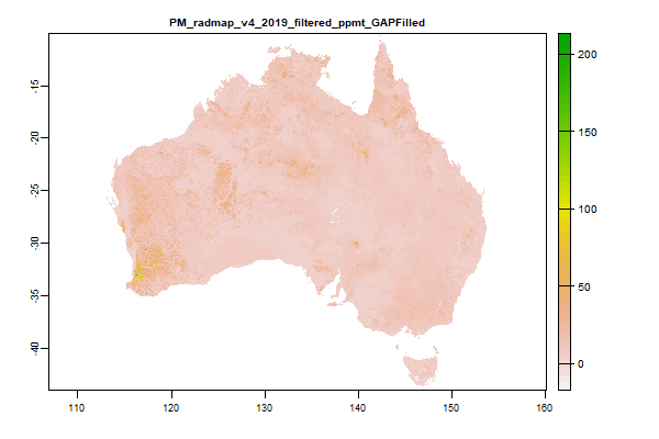
4.4 Gb | PM_radmap_v4_2019_filtered_ppmt_GAPFilled |
Name : PM_radmap_v4_2019_filtered_ppmt_GAPFilled
Description : Radiometric grid of Australia (Radmap) v4 2019 - Thorium
Source : Geoscience Australia
Metadata : https://shiny.esoil.io/Apps/Covariates?Attribute=Parent_Material&Name=PM_radmap_v4_2019_filtered_ppmt_GAPFilled&Resolution=90m
Units : ppm
SCORPAN : Parent_Material
Original Resolution : 0.001 Degrees
|
Radiometric grid of Australia (Radmap) v4 2019 - Thorium | MetaData |
 Click to enlarge the image
|
|
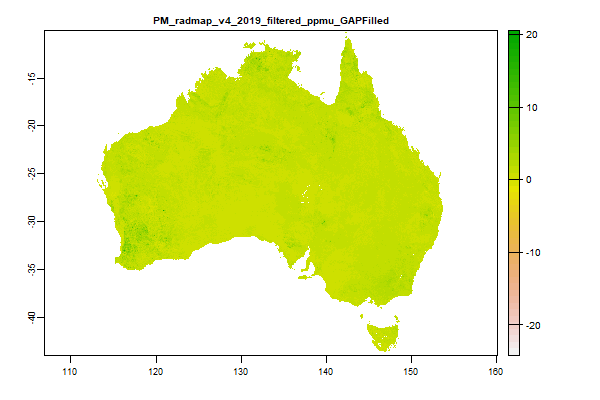
4.5 Gb | PM_radmap_v4_2019_filtered_ppmu_GAPFilled |
Name : PM_radmap_v4_2019_filtered_ppmu_GAPFilled
Description : Radiometric grid of Australia (Radmap) v4 2019 - Uranium
Source : Geoscience Australia
Metadata : https://shiny.esoil.io/Apps/Covariates?Attribute=Parent_Material&Name=PM_radmap_v4_2019_filtered_ppmu_GAPFilled&Resolution=90m
Units : ppm
SCORPAN : Parent_Material
Original Resolution : 0.001 Degrees
|
Radiometric grid of Australia (Radmap) v4 2019 - Uranium | MetaData |
 Click to enlarge the image
|
|
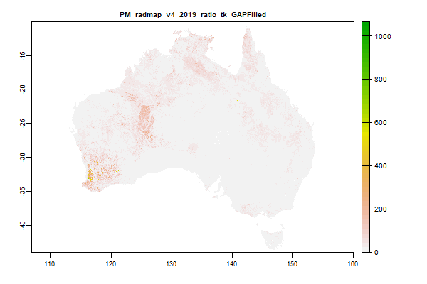
4.5 Gb | PM_radmap_v4_2019_ratio_tk_GAPFilled |
Name : PM_radmap_v4_2019_ratio_tk_GAPFilled
Description : Radiometric grid of Australia (Radmap) v4 2019 - Thorium Potassium ratio
Source : Geoscience Australia
Metadata : https://shiny.esoil.io/Apps/Covariates?Attribute=Parent_Material&Name=PM_radmap_v4_2019_ratio_tk_GAPFilled&Resolution=90m
Units : ratio
SCORPAN : Parent_Material
Original Resolution : 0.001 Degrees
|
Radiometric grid of Australia (Radmap) v4 2019 - Thorium Potassium ratio | MetaData |
 Click to enlarge the image
|
|
4.6 Gb | PM_radmap_v4_2019_ratio_u2t_GAPFilled |
Name : PM_radmap_v4_2019_ratio_u2t_GAPFilled
Description : Radiometric grid of Australia (Radmap) v4 2019 - Uranium Thorium ratio
Source : Geoscience Australia
Metadata : https://shiny.esoil.io/Apps/Covariates?Attribute=Parent_Material&Name=PM_radmap_v4_2019_ratio_u2t_GAPFilled&Resolution=90m
Units : ratio
SCORPAN : Parent_Material
Original Resolution : 0.001 Degrees
|
Radiometric grid of Australia (Radmap) v4 2019 - Uranium Thorium ratio | MetaData |
 Click to enlarge the image
|
|
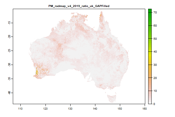
4.6 Gb | PM_radmap_v4_2019_ratio_uk_GAPFilled |
Name : PM_radmap_v4_2019_ratio_uk_GAPFilled
Description : Radiometric grid of Australia (Radmap) v4 2019 - Uranium Potassium ratio
Source : Geoscience Australia
Metadata : https://shiny.esoil.io/Apps/Covariates?Attribute=Parent_Material&Name=PM_radmap_v4_2019_ratio_uk_GAPFilled&Resolution=90m
Units : ratio
SCORPAN : Parent_Material
Original Resolution : 0.001 Degrees
|
Radiometric grid of Australia (Radmap) v4 2019 - Uranium Potassium ratio | MetaData |
 Click to enlarge the image
|
|
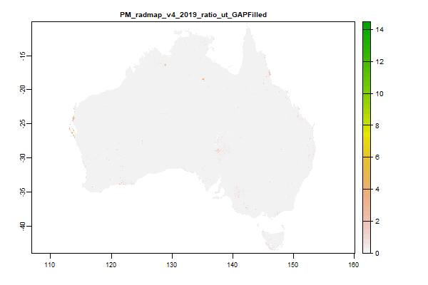
4.6 Gb | PM_radmap_v4_2019_ratio_ut_GAPFilled |
Name : PM_radmap_v4_2019_ratio_ut_GAPFilled
Description : Radiometric grid of Australia (Radmap) v4 2019 - Uranium Thorium ratio
Source : Geoscience Australia
Metadata : https://shiny.esoil.io/Apps/Covariates?Attribute=Parent_Material&Name=PM_radmap_v4_2019_ratio_ut_GAPFilled&Resolution=90m
Units : ratio
SCORPAN : Parent_Material
Original Resolution : 0.001 Degrees
|
Radiometric grid of Australia (Radmap) v4 2019 - Uranium Thorium ratio | MetaData |
 Click to enlarge the image
|
|
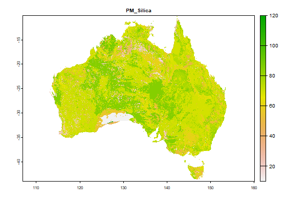
69.5 Mb | PM_Silica |
Name : PM_Silica
Description : Estimated silica content of the geology
Source : CSIRO
Metadata : https://shiny.esoil.io/Apps/Covariates?Attribute=Parent_Material&Name=PM_Silica&Resolution=90m
Units : none
SCORPAN : Parent_Material
Original Resolution : NA
|
Estimated silica content of the geology | MetaData |
 Click to enlarge the image
|
|
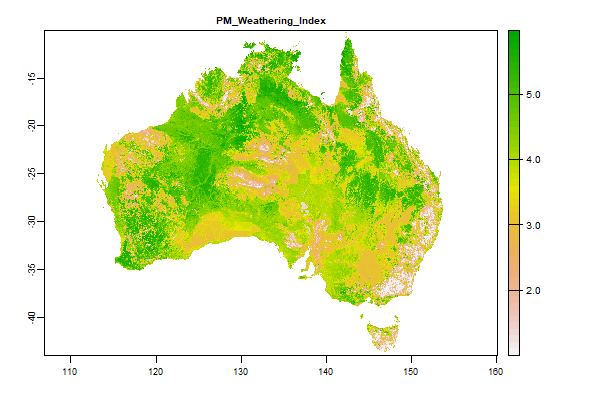
4.5 Gb | PM_Weathering_Index |
Name : PM_Weathering_Index
Description : Weathering Index
Source : Geoscience Australia
Metadata : https://shiny.esoil.io/Apps/Covariates?Attribute=Parent_Material&Name=PM_Weathering_Index&Resolution=90m
Units : none
SCORPAN : Parent_Material
Original Resolution : 90m
|
Weathering Index | MetaData |
 Click to enlarge the image
|
|
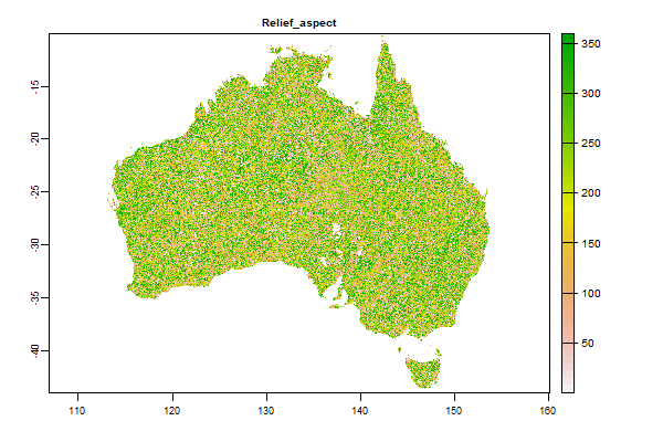
5.5 Gb | Relief_aspect |
Name : Relief_aspect
Description : Aspect derived from 3" SRTM DEM-S
Source : CSIRO
Metadata : https://shiny.esoil.io/Apps/Covariates?Attribute=Relief&Name=Relief_aspect&Resolution=90m
Units : none
SCORPAN : Relief
Original Resolution : 3 arc-second
|
Aspect derived from 3" SRTM DEM-S | MetaData |
 Click to enlarge the image
|
|
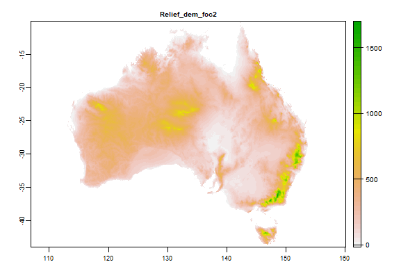
2.9 Gb | Relief_dem_foc2 |
Name : Relief_dem_foc2
Description : Not sure what this one is - some manner of focal average most likely
Source : CSIRO
Metadata : https://shiny.esoil.io/Apps/Covariates?Attribute=Relief&Name=Relief_dem_foc2&Resolution=90m
Units : none
SCORPAN : Relief
Original Resolution : 3 arc-second
|
Not sure what this one is - some manner of focal average most likely | MetaData |
 Click to enlarge the image
|
|
4.1 Gb | Relief_dems_3s_mosaic1 |
Name : Relief_dems_3s_mosaic1
Description : 3 second SRTM Derived Digital Elevation Model (DEM) Version 1.0
Source : Geoscience Australia
Metadata : https://shiny.esoil.io/Apps/Covariates?Attribute=Relief&Name=Relief_dems_3s_mosaic1&Resolution=90m
Units : none
SCORPAN : Relief
Original Resolution : 3 arc-second
|
3 second SRTM Derived Digital Elevation Model (DEM) Version 1.0 | MetaData |
 Click to enlarge the image
|
|
2.5 Gb | Relief_eastslopes |
Name : Relief_eastslopes
Description : Defines east facing slope areas whereby eastness and the interaction with slope is calculated (eastness*slope)
Source : NRE (Tas gov)
Metadata : https://shiny.esoil.io/Apps/Covariates?Attribute=Relief&Name=Relief_eastslopes&Resolution=90m
Units : standardised scale: 0-1
SCORPAN : Relief
Original Resolution : 3 arc-second
|
Defines east facing slope areas whereby eastness and the interaction with slope is calculated (eastness*slope) | MetaData |
 Click to enlarge the image
|
|
3.7 Gb | Relief_elev_focalrange1000m_3s |
Name : Relief_elev_focalrange1000m_3s
Description : Relief - Elevation Range over 1000 m derived from 3" SRTM DEM-S
Source : CSIRO
Metadata : https://shiny.esoil.io/Apps/Covariates?Attribute=Relief&Name=Relief_elev_focalrange1000m_3s&Resolution=90m
Units : none
SCORPAN : Relief
Original Resolution : 3 arc-second
|
Relief - Elevation Range over 1000 m derived from 3" SRTM DEM-S | MetaData |
 Click to enlarge the image
|
|
4.2 Gb | Relief_elev_focalrange300m_3s |
Name : Relief_elev_focalrange300m_3s
Description : Relief - Elevation Range over 300 m derived from 1" SRTM DEM-S
Source : CSIRO
Metadata : https://shiny.esoil.io/Apps/Covariates?Attribute=Relief&Name=Relief_elev_focalrange300m_3s&Resolution=90m
Units : none
SCORPAN : Relief
Original Resolution : 3 arc-second
|
Relief - Elevation Range over 300 m derived from 1" SRTM DEM-S | MetaData |
 Click to enlarge the image
|
|
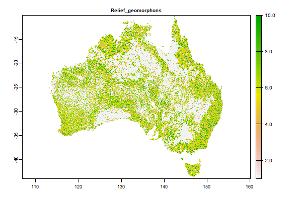
454.1 Mb | Relief_geomorphons |
Name : Relief_geomorphons
Description : Geomorphons
Source : CSIRO
Metadata : https://shiny.esoil.io/Apps/Covariates?Attribute=Relief&Name=Relief_geomorphons&Resolution=90m
Units : none
SCORPAN : Relief
Original Resolution : 3 arc-second
|
Geomorphons | MetaData |
 Click to enlarge the image
|
|
583.2 Mb | Relief_hillshade |
Name : Relief_hillshade
Description : Hillshade derived from 3 second SRTM Derived Digital Elevation Model (DEM) Version 1.0.
Source : NRE (Tas gov)
Metadata : https://shiny.esoil.io/Apps/Covariates?Attribute=Relief&Name=Relief_hillshade&Resolution=90m
Units : standardised scale: 0-1
SCORPAN : Relief
Original Resolution : 3 arc-second
|
Hillshade derived from 3 second SRTM Derived Digital Elevation Model (DEM) Version 1.0. | MetaData |
 Click to enlarge the image
|
|
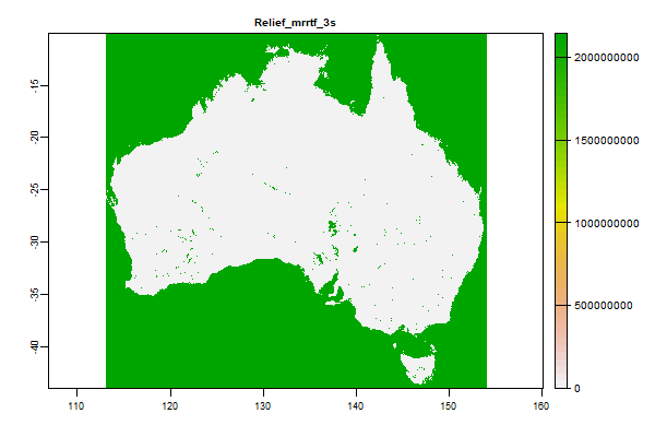
466.2 Mb | Relief_mrrtf_3s |
Name : Relief_mrrtf_3s
Description : Multi-resolution Ridge Top Flatness (MrRTF)
Source : CSIRO
Metadata : https://shiny.esoil.io/Apps/Covariates?Attribute=Relief&Name=Relief_mrrtf_3s&Resolution=90m
Units : none
SCORPAN : Relief
Original Resolution : 1 arc-second
|
Multi-resolution Ridge Top Flatness (MrRTF) | MetaData |
 Click to enlarge the image
|
|
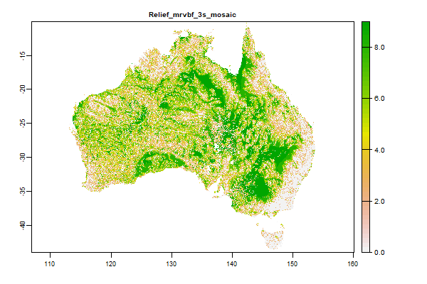
253.4 Mb | Relief_mrvbf_3s_mosaic |
Name : Relief_mrvbf_3s_mosaic
Description : Multi-resolution Valley Bottom Flatness (MrVBF)
Source : CSIRO
Metadata : https://shiny.esoil.io/Apps/Covariates?Attribute=Relief&Name=Relief_mrvbf_3s_mosaic&Resolution=90m
Units : none
SCORPAN : Relief
Original Resolution : 3 arc-second
|
Multi-resolution Valley Bottom Flatness (MrVBF) | MetaData |
 Click to enlarge the image
|
|
2.5 Gb | Relief_northslopes |
Name : Relief_northslopes
Description : Defines north facing slope areas whereby northness and the interaction with slope is calculated (northness*slope)
Source : NRE (Tas gov)
Metadata : https://shiny.esoil.io/Apps/Covariates?Attribute=Relief&Name=Relief_northslopes&Resolution=90m
Units : standardised scale: 0-1
SCORPAN : Relief
Original Resolution : 3 arc-second
|
Defines north facing slope areas whereby northness and the interaction with slope is calculated (northness*slope) | MetaData |
 Click to enlarge the image
|
|
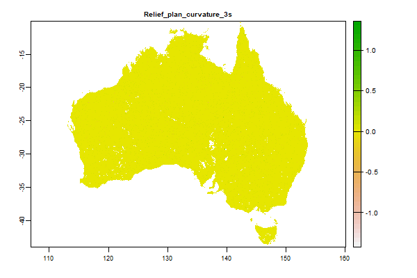
6 Gb | Relief_plan_curvature_3s |
Name : Relief_plan_curvature_3s
Description : Plan Curvature derived from 1" SRTM DEM-S
Source : CSIRO
Metadata : https://shiny.esoil.io/Apps/Covariates?Attribute=Relief&Name=Relief_plan_curvature_3s&Resolution=90m
Units : none
SCORPAN : Relief
Original Resolution : 3 arc-second
|
Plan Curvature derived from 1" SRTM DEM-S | MetaData |
 Click to enlarge the image
|
|
5.9 Gb | Relief_profile_curvature_3 |
Name : Relief_profile_curvature_3
Description : Profile Curvature derived from 1" SRTM DEM-S
Source : CSIRO
Metadata : https://shiny.esoil.io/Apps/Covariates?Attribute=Relief&Name=Relief_profile_curvature_3&Resolution=90m
Units : none
SCORPAN : Relief
Original Resolution : 3 arc-second
|
Profile Curvature derived from 1" SRTM DEM-S | MetaData |
 Click to enlarge the image
|
|
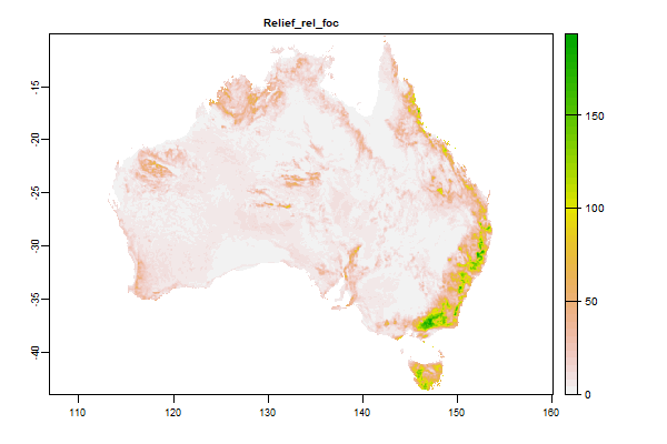
3.7 Gb | Relief_rel_foc |
Name : Relief_rel_foc
Description : NA
Source : CSIRO
Metadata : https://shiny.esoil.io/Apps/Covariates?Attribute=Relief&Name=Relief_rel_foc&Resolution=90m
Units : none
SCORPAN : Relief
Original Resolution : 3 arc-second
|
NA | MetaData |
 Click to enlarge the image
|
|
4.3 Gb | Relief_roughness |
Name : Relief_roughness
Description : Landscape Roughness
Source : Interpreted
Metadata : https://shiny.esoil.io/Apps/Covariates?Attribute=Relief&Name=Relief_roughness&Resolution=90m
Units : none
SCORPAN : Relief
Original Resolution : 3 arc-second
|
Landscape Roughness | MetaData |
 Click to enlarge the image
|
|
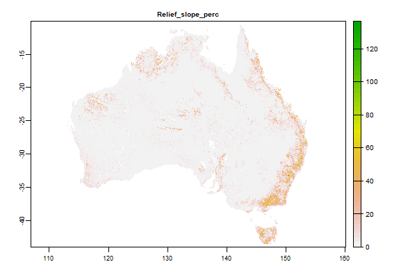
5.5 Gb | Relief_slope_perc |
Name : Relief_slope_perc
Description : Slope derived from 1" SRTM DEM-S
Source : CSIRO
Metadata : https://shiny.esoil.io/Apps/Covariates?Attribute=Relief&Name=Relief_slope_perc&Resolution=90m
Units : none
SCORPAN : Relief
Original Resolution : 3 arc-second
|
Slope derived from 1" SRTM DEM-S | MetaData |
 Click to enlarge the image
|
|
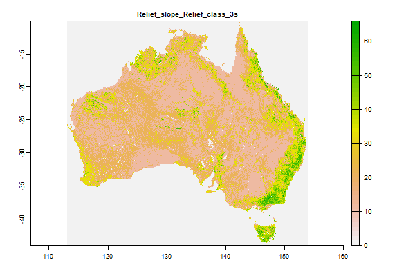
188.3 Mb | Relief_slope_Relief_class_3s |
Name : Relief_slope_Relief_class_3s
Description : Slope Relief Classification derived from 1" SRTM DEM-S
Source : CSIRO
Metadata : https://shiny.esoil.io/Apps/Covariates?Attribute=Relief&Name=Relief_slope_Relief_class_3s&Resolution=90m
Units : none
SCORPAN : Relief
Original Resolution : 3 arc-second
|
Slope Relief Classification derived from 1" SRTM DEM-S | MetaData |
 Click to enlarge the image
|
|
5.1 Gb | Relief_slopepct_focalmedian300m_3s |
Name : Relief_slopepct_focalmedian300m_3s
Description : Median of Percent Slope over 300 m derived from 1" SRTM DEM-S
Source : CSIRO
Metadata : https://shiny.esoil.io/Apps/Covariates?Attribute=Relief&Name=Relief_slopepct_focalmedian300m_3s&Resolution=90m
Units : none
SCORPAN : Relief
Original Resolution : 3 arc-second
|
Median of Percent Slope over 300 m derived from 1" SRTM DEM-S | MetaData |
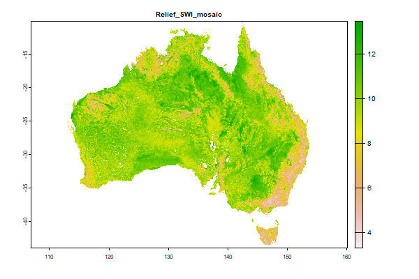 Click to enlarge the image
|
|
4.1 Gb | Relief_SWI_mosaic |
Name : Relief_SWI_mosaic
Description : SAGA Wetness Index derived from 3 second SRTM Derived Digital Elevation Model (DEM) Version 1.0. This is similar to the 'Topographic Wetness Index' (Relief_twi_3s), but it is based on a modified
Source : NRE (Tas gov)
Metadata : https://shiny.esoil.io/Apps/Covariates?Attribute=Relief&Name=Relief_SWI_mosaic&Resolution=90m
Units : standardised scale: 0-1
SCORPAN : Relief
Original Resolution : 3 arc-second
|
SAGA Wetness Index derived from 3 second SRTM Derived Digital Elevation Model (DEM) Version 1.0. This is similar to the 'Topographic Wetness Index' (Relief_twi_3s), but it is based on a modified | MetaData |
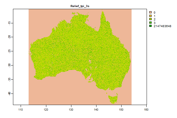 Click to enlarge the image
|
|
384.7 Mb | Relief_tpi_3s |
Name : Relief_tpi_3s
Description : Topographic Position Index derived from 1" SRTM DEM-S
Source : CSIRO
Metadata : https://shiny.esoil.io/Apps/Covariates?Attribute=Relief&Name=Relief_tpi_3s&Resolution=90m
Units : none
SCORPAN : Relief
Original Resolution : 3 arc-second
|
Topographic Position Index derived from 1" SRTM DEM-S | MetaData |
 Click to enlarge the image
|
|
5.1 Gb | Relief_twi_3s |
Name : Relief_twi_3s
Description : Topographic Wetness Index derived from 1" SRTM DEM-H
Source : CSIRO
Metadata : https://shiny.esoil.io/Apps/Covariates?Attribute=Relief&Name=Relief_twi_3s&Resolution=90m
Units : none
SCORPAN : Relief
Original Resolution : 3 arc-second
|
Topographic Wetness Index derived from 1" SRTM DEM-H | MetaData |
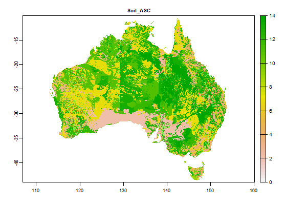 Click to enlarge the image
|
|
49.5 Mb | Soil_ASC |
Name : Soil_ASC
Description : ASRIS Australian Soil Classification - Dominant Soil Order (250m raster)
Source : CSIRO
Metadata : https://shiny.esoil.io/Apps/Covariates?Attribute=Soil&Name=Soil_ASC&Resolution=90m
Units : none
SCORPAN : Soil
Original Resolution : NA
|
ASRIS Australian Soil Classification - Dominant Soil Order (250m raster) | MetaData |
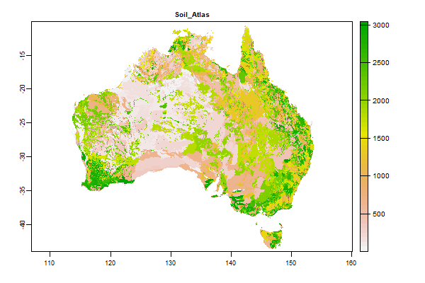 Click to enlarge the image
|
|
57.3 Mb | Soil_Atlas |
Name : Soil_Atlas
Description : Atlas of Australian Soils (1:2 million)
Source : CSIRO
Metadata : https://shiny.esoil.io/Apps/Covariates?Attribute=Soil&Name=Soil_Atlas&Resolution=90m
Units : none
SCORPAN : Soil
Original Resolution : none
|
Atlas of Australian Soils (1:2 million) | MetaData |
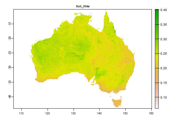 Click to enlarge the image
|
|
4.8 Gb | Soil_Illite |
Name : Soil_Illite
Description : Maps clay minerals – illite in Australian soils - 0 - 20cm
Source : CSIRO
Metadata : https://shiny.esoil.io/Apps/Covariates?Attribute=Soil&Name=Soil_Illite&Resolution=90m
Units : percent
SCORPAN : Soil
Original Resolution : 0.0008333 Degrees
|
Maps clay minerals – illite in Australian soils - 0 - 20cm | MetaData |
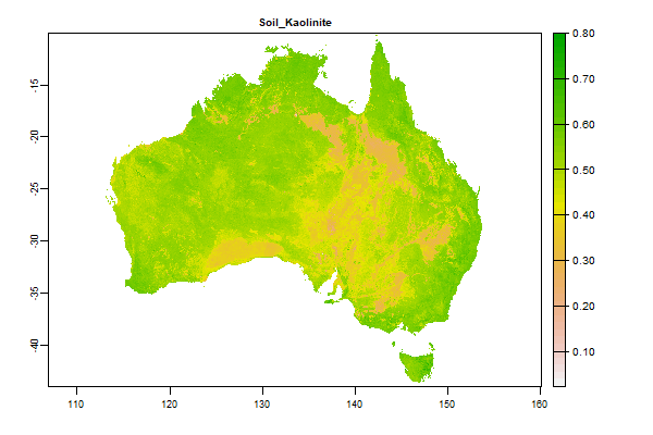 Click to enlarge the image
|
|
4.5 Gb | Soil_Kaolinite |
Name : Soil_Kaolinite
Description : Maps clay minerals – kaolinite in Australian soils - 0 - 20cm
Source : CSIRO
Metadata : https://shiny.esoil.io/Apps/Covariates?Attribute=Soil&Name=Soil_Kaolinite&Resolution=90m
Units : percent
SCORPAN : Soil
Original Resolution : 0.0008333 Degrees
|
Maps clay minerals – kaolinite in Australian soils - 0 - 20cm | MetaData |
 Click to enlarge the image
|
|
4.8 Gb | Soil_Smectite |
Name : Soil_Smectite
Description : Maps clay minerals – smectite in Australian soils - 0 - 20cm
Source : CSIRO
Metadata : https://shiny.esoil.io/Apps/Covariates?Attribute=Soil&Name=Soil_Smectite&Resolution=90m
Units : percent
SCORPAN : Soil
Original Resolution : 0.0008333 Degrees
|
Maps clay minerals – smectite in Australian soils - 0 - 20cm | MetaData |
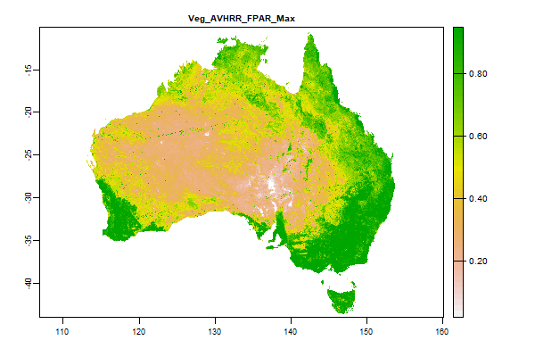 Click to enlarge the image
|
|
459.4 Mb | Veg_AVHRR_FPAR_Max |
Name : Veg_AVHRR_FPAR_Max
Description : Fraction of Photosynthetically Active Radiation (FPAR) - AVHRR CSIRO Land and Water algorithm Australia coverage - Maximum Value in Timeseries
Source : Time Series Remote Sensing Team, CSIRO Land and Water
Metadata : https://shiny.esoil.io/Apps/Covariates?Attribute=Organisms&Name=Veg_AVHRR_FPAR_Max&Resolution=90m
Units : percent
SCORPAN : Organisms
Original Resolution : 0.01 Degrees
|
Fraction of Photosynthetically Active Radiation (FPAR) - AVHRR CSIRO Land and Water algorithm Australia coverage - Maximum Value in Timeseries | MetaData |
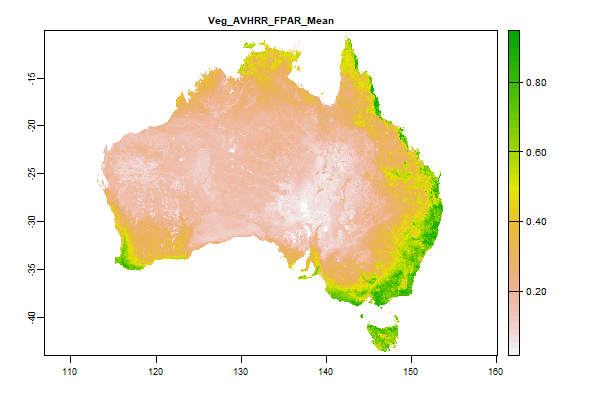 Click to enlarge the image
|
|
870.8 Mb | Veg_AVHRR_FPAR_Mean |
Name : Veg_AVHRR_FPAR_Mean
Description : Fraction of Photosynthetically Active Radiation (FPAR) - AVHRR CSIRO Land and Water algorithm Australia coverage - Mean Value in Timeseries
Source : Time Series Remote Sensing Team, CSIRO Land and Water
Metadata : https://shiny.esoil.io/Apps/Covariates?Attribute=Organisms&Name=Veg_AVHRR_FPAR_Mean&Resolution=90m
Units : percent
SCORPAN : Organisms
Original Resolution : 0.01 Degrees
|
Fraction of Photosynthetically Active Radiation (FPAR) - AVHRR CSIRO Land and Water algorithm Australia coverage - Mean Value in Timeseries | MetaData |
 Click to enlarge the image
|
|
398.4 Mb | Veg_AVHRR_FPAR_Median |
Name : Veg_AVHRR_FPAR_Median
Description : Fraction of Photosynthetically Active Radiation (FPAR) - AVHRR CSIRO Land and Water algorithm Australia coverage - Median Value in Timeseries
Source : Time Series Remote Sensing Team, CSIRO Land and Water
Metadata : https://shiny.esoil.io/Apps/Covariates?Attribute=Organisms&Name=Veg_AVHRR_FPAR_Median&Resolution=90m
Units : percent
SCORPAN : Organisms
Original Resolution : 0.01 Degrees
|
Fraction of Photosynthetically Active Radiation (FPAR) - AVHRR CSIRO Land and Water algorithm Australia coverage - Median Value in Timeseries | MetaData |
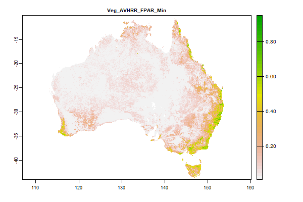 Click to enlarge the image
|
|
388.6 Mb | Veg_AVHRR_FPAR_Min |
Name : Veg_AVHRR_FPAR_Min
Description : Fraction of Photosynthetically Active Radiation (FPAR) - AVHRR CSIRO Land and Water algorithm Australia coverage - Minimum Value in Timeseries
Source : Time Series Remote Sensing Team, CSIRO Land and Water
Metadata : https://shiny.esoil.io/Apps/Covariates?Attribute=Organisms&Name=Veg_AVHRR_FPAR_Min&Resolution=90m
Units : percent
SCORPAN : Organisms
Original Resolution : 0.01 Degrees
|
Fraction of Photosynthetically Active Radiation (FPAR) - AVHRR CSIRO Land and Water algorithm Australia coverage - Minimum Value in Timeseries | MetaData |
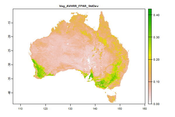 Click to enlarge the image
|
|
890.2 Mb | Veg_AVHRR_FPAR_StdDev |
Name : Veg_AVHRR_FPAR_StdDev
Description : Fraction of Photosynthetically Active Radiation (FPAR) - AVHRR CSIRO Land and Water algorithm Australia coverage - Standard Deviation of Value in Timeseries
Source : Time Series Remote Sensing Team, CSIRO Land and Water
Metadata : https://shiny.esoil.io/Apps/Covariates?Attribute=Organisms&Name=Veg_AVHRR_FPAR_StdDev&Resolution=90m
Units : percent
SCORPAN : Organisms
Original Resolution : 0.01 Degrees
|
Fraction of Photosynthetically Active Radiation (FPAR) - AVHRR CSIRO Land and Water algorithm Australia coverage - Standard Deviation of Value in Timeseries | MetaData |
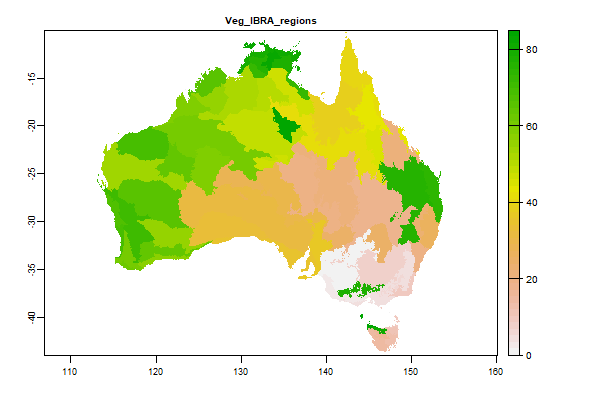 Click to enlarge the image
|
|
22 Mb | Veg_IBRA_regions |
Name : Veg_IBRA_regions
Description : Interim Biogeographic Regionalisation for Australia (IBRA) Version 6_1
Source : Australian Government Department of the Environment, Water, Heritage and the Arts
Metadata : https://shiny.esoil.io/Apps/Covariates?Attribute=Organisms&Name=Veg_IBRA_regions&Resolution=90m
Units : NA
SCORPAN : Organisms
Original Resolution : NA
|
Interim Biogeographic Regionalisation for Australia (IBRA) Version 6_1 | MetaData |
 Click to enlarge the image
|
|
172.1 Mb | Veg_LandCoverTrend_evi_class |
Name : Veg_LandCoverTrend_evi_class
Description : National Dynamic Land Cover Dataset Class
Source : Geoscience Australia
Metadata : https://shiny.esoil.io/Apps/Covariates?Attribute=Organisms&Name=Veg_LandCoverTrend_evi_class&Resolution=90m
Units : None
SCORPAN : Organisms
Original Resolution : 0.00234899 Degrees
|
National Dynamic Land Cover Dataset Class | MetaData |
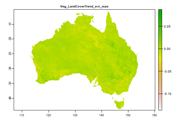 Click to enlarge the image
|
|
2.7 Gb | Veg_LandCoverTrend_evi_max |
Name : Veg_LandCoverTrend_evi_max
Description : National Dynamic Land Cover Dataset Maximum of the timeseries 2000 - 2008
Source : Geoscience Australia
Metadata : https://shiny.esoil.io/Apps/Covariates?Attribute=Organisms&Name=Veg_LandCoverTrend_evi_max&Resolution=90m
Units : None
SCORPAN : Organisms
Original Resolution : 0.00234899 Degrees
|
National Dynamic Land Cover Dataset Maximum of the timeseries 2000 - 2008 | MetaData |
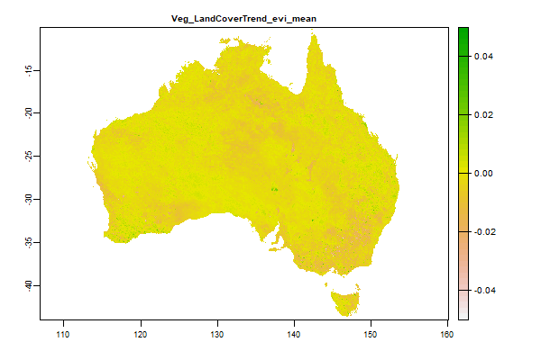 Click to enlarge the image
|
|
2.7 Gb | Veg_LandCoverTrend_evi_mean |
Name : Veg_LandCoverTrend_evi_mean
Description : National Dynamic Land Cover Dataset Mean of the timeseries 2000 - 2008
Source : Geoscience Australia
Metadata : https://shiny.esoil.io/Apps/Covariates?Attribute=Organisms&Name=Veg_LandCoverTrend_evi_mean&Resolution=90m
Units : None
SCORPAN : Organisms
Original Resolution : 0.00234899 Degrees
|
National Dynamic Land Cover Dataset Mean of the timeseries 2000 - 2008 | MetaData |
 Click to enlarge the image
|
|
2.8 Gb | Veg_LandCoverTrend_evi_min |
Name : Veg_LandCoverTrend_evi_min
Description : National Dynamic Land Cover Dataset Minimum of the timeseries 2000 - 2008
Source : Geoscience Australia
Metadata : https://shiny.esoil.io/Apps/Covariates?Attribute=Organisms&Name=Veg_LandCoverTrend_evi_min&Resolution=90m
Units : None
SCORPAN : Organisms
Original Resolution : 0.00234899 Degrees
|
National Dynamic Land Cover Dataset Minimum of the timeseries 2000 - 2008 | MetaData |
 Click to enlarge the image
|
|
2 Gb | Veg_Landsat30Bare_1 |
Name : Veg_Landsat30Bare_1
Description : Barest Earth Landsat Imagery - Landsat30Bare_1
Source : Geoscience Australia
Metadata : https://shiny.esoil.io/Apps/Covariates?Attribute=Organisms&Name=Veg_Landsat30Bare_1&Resolution=90m
Units : none
SCORPAN : Organisms
Original Resolution : 25m
|
Barest Earth Landsat Imagery - Landsat30Bare_1 | MetaData |
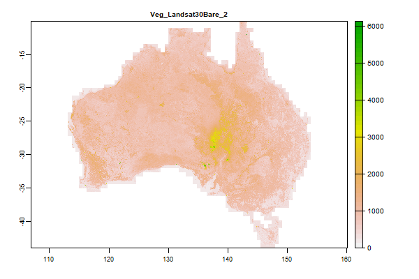 Click to enlarge the image
|
|
2.2 Gb | Veg_Landsat30Bare_2 |
Name : Veg_Landsat30Bare_2
Description : Barest Earth Landsat Imagery - Landsat30Bare_2
Source : Geoscience Australia
Metadata : https://shiny.esoil.io/Apps/Covariates?Attribute=Organisms&Name=Veg_Landsat30Bare_2&Resolution=90m
Units : none
SCORPAN : Organisms
Original Resolution : 25m
|
Barest Earth Landsat Imagery - Landsat30Bare_2 | MetaData |
 Click to enlarge the image
|
|
2.4 Gb | Veg_Landsat30Bare_3 |
Name : Veg_Landsat30Bare_3
Description : Barest Earth Landsat Imagery - Landsat30Bare_3
Source : Geoscience Australia
Metadata : https://shiny.esoil.io/Apps/Covariates?Attribute=Organisms&Name=Veg_Landsat30Bare_3&Resolution=90m
Units : none
SCORPAN : Organisms
Original Resolution : 25m
|
Barest Earth Landsat Imagery - Landsat30Bare_3 | MetaData |
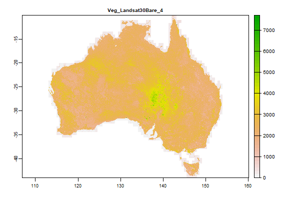 Click to enlarge the image
|
|
2.5 Gb | Veg_Landsat30Bare_4 |
Name : Veg_Landsat30Bare_4
Description : Barest Earth Landsat Imagery - Landsat30Bare_4
Source : Geoscience Australia
Metadata : https://shiny.esoil.io/Apps/Covariates?Attribute=Organisms&Name=Veg_Landsat30Bare_4&Resolution=90m
Units : none
SCORPAN : Organisms
Original Resolution : 25m
|
Barest Earth Landsat Imagery - Landsat30Bare_4 | MetaData |
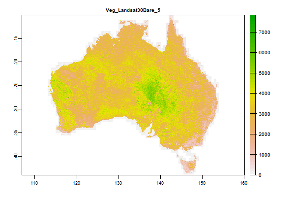 Click to enlarge the image
|
|
2.6 Gb | Veg_Landsat30Bare_5 |
Name : Veg_Landsat30Bare_5
Description : Barest Earth Landsat Imagery - Landsat30Bare_5
Source : Geoscience Australia
Metadata : https://shiny.esoil.io/Apps/Covariates?Attribute=Organisms&Name=Veg_Landsat30Bare_5&Resolution=90m
Units : none
SCORPAN : Organisms
Original Resolution : 25m
|
Barest Earth Landsat Imagery - Landsat30Bare_5 | MetaData |
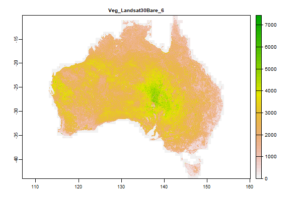 Click to enlarge the image
|
|
2.6 Gb | Veg_Landsat30Bare_6 |
Name : Veg_Landsat30Bare_6
Description : Barest Earth Landsat Imagery - Landsat30Bare_6
Source : Geoscience Australia
Metadata : https://shiny.esoil.io/Apps/Covariates?Attribute=Organisms&Name=Veg_Landsat30Bare_6&Resolution=90m
Units : none
SCORPAN : Organisms
Original Resolution : 25m
|
Barest Earth Landsat Imagery - Landsat30Bare_6 | MetaData |
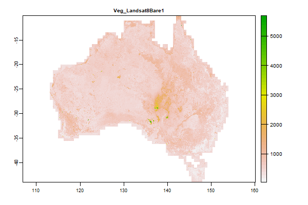 Click to enlarge the image
|
|
2.1 Gb | Veg_Landsat8Bare1 |
Name : Veg_Landsat8Bare1
Description : Barest Earth Landsat Imagery - Landsat8Bare1
Source : Geoscience Australia
Metadata : https://shiny.esoil.io/Apps/Covariates?Attribute=Organisms&Name=Veg_Landsat8Bare1&Resolution=90m
Units : none
SCORPAN : Organisms
Original Resolution : 25m
|
Barest Earth Landsat Imagery - Landsat8Bare1 | MetaData |
 Click to enlarge the image
|
|
2.3 Gb | Veg_Landsat8Bare2 |
Name : Veg_Landsat8Bare2
Description : Barest Earth Landsat Imagery - Landsat8Bare2
Source : Geoscience Australia
Metadata : https://shiny.esoil.io/Apps/Covariates?Attribute=Organisms&Name=Veg_Landsat8Bare2&Resolution=90m
Units : none
SCORPAN : Organisms
Original Resolution : 25m
|
Barest Earth Landsat Imagery - Landsat8Bare2 | MetaData |
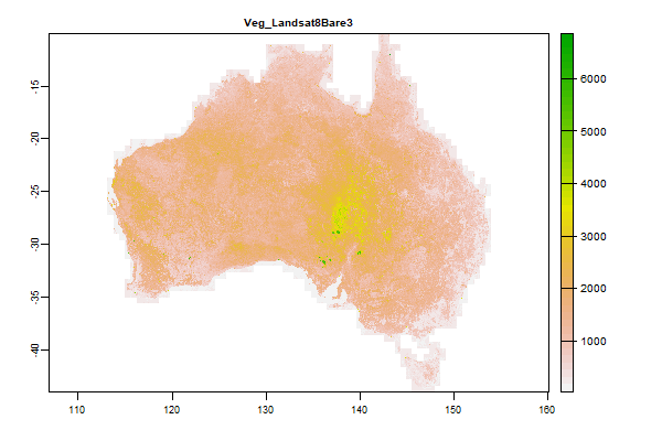 Click to enlarge the image
|
|
2.5 Gb | Veg_Landsat8Bare3 |
Name : Veg_Landsat8Bare3
Description : Barest Earth Landsat Imagery - Landsat8Bare3
Source : Geoscience Australia
Metadata : https://shiny.esoil.io/Apps/Covariates?Attribute=Organisms&Name=Veg_Landsat8Bare3&Resolution=90m
Units : none
SCORPAN : Organisms
Original Resolution : 25m
|
Barest Earth Landsat Imagery - Landsat8Bare3 | MetaData |
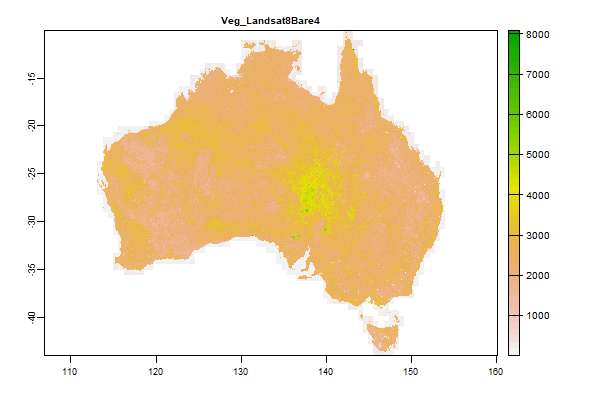 Click to enlarge the image
|
|
2.6 Gb | Veg_Landsat8Bare4 |
Name : Veg_Landsat8Bare4
Description : Barest Earth Landsat Imagery - Landsat8Bare4
Source : Geoscience Australia
Metadata : https://shiny.esoil.io/Apps/Covariates?Attribute=Organisms&Name=Veg_Landsat8Bare4&Resolution=90m
Units : none
SCORPAN : Organisms
Original Resolution : 25m
|
Barest Earth Landsat Imagery - Landsat8Bare4 | MetaData |
 Click to enlarge the image
|
|
2.6 Gb | Veg_Landsat8Bare5 |
Name : Veg_Landsat8Bare5
Description : Barest Earth Landsat Imagery - Landsat8Bare5
Source : Geoscience Australia
Metadata : https://shiny.esoil.io/Apps/Covariates?Attribute=Organisms&Name=Veg_Landsat8Bare5&Resolution=90m
Units : none
SCORPAN : Organisms
Original Resolution : 25m
|
Barest Earth Landsat Imagery - Landsat8Bare5 | MetaData |
 Click to enlarge the image
|
|
2.7 Gb | Veg_Landsat8Bare6 |
Name : Veg_Landsat8Bare6
Description : Barest Earth Landsat Imagery - Landsat8Bare6
Source : Geoscience Australia
Metadata : https://shiny.esoil.io/Apps/Covariates?Attribute=Organisms&Name=Veg_Landsat8Bare6&Resolution=90m
Units : none
SCORPAN : Organisms
Original Resolution : 25m
|
Barest Earth Landsat Imagery - Landsat8Bare6 | MetaData |
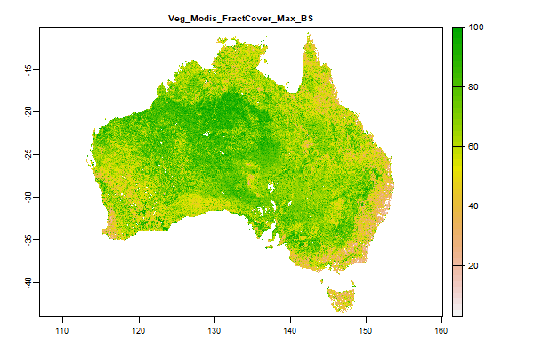 Click to enlarge the image
|
|
339 Mb | Veg_Modis_FractCover_Max_BS |
Name : Veg_Modis_FractCover_Max_BS
Description : Fractional cover - MODIS CSIRO Land and Water algorithm Australia coverage - Bare Soil - Maximum
Source : CSIRO CLW
Metadata : https://shiny.esoil.io/Apps/Covariates?Attribute=Organisms&Name=Veg_Modis_FractCover_Max_BS&Resolution=90m
Units : percent
SCORPAN : Organisms
Original Resolution : 500m
|
Fractional cover - MODIS CSIRO Land and Water algorithm Australia coverage - Bare Soil - Maximum | MetaData |
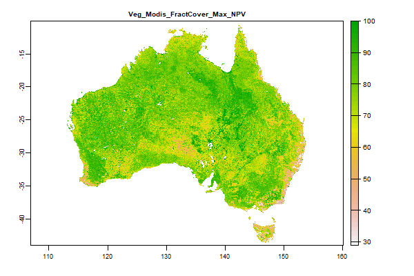 Click to enlarge the image
|
|
293.8 Mb | Veg_Modis_FractCover_Max_NPV |
Name : Veg_Modis_FractCover_Max_NPV
Description : Fractional cover - MODIS CSIRO Land and Water algorithm Australia coverage - Photosynthetic Vegetation - Maximum
Source : CSIRO CLW
Metadata : https://shiny.esoil.io/Apps/Covariates?Attribute=Organisms&Name=Veg_Modis_FractCover_Max_NPV&Resolution=90m
Units : percent
SCORPAN : Organisms
Original Resolution : 500m
|
Fractional cover - MODIS CSIRO Land and Water algorithm Australia coverage - Photosynthetic Vegetation - Maximum | MetaData |
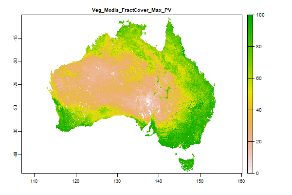 Click to enlarge the image
|
|
265.1 Mb | Veg_Modis_FractCover_Max_PV |
Name : Veg_Modis_FractCover_Max_PV
Description : Fractional cover - MODIS CSIRO Land and Water algorithm Australia coverage - Non Photosynthetic Vegetation - Maximum
Source : CSIRO CLW
Metadata : https://shiny.esoil.io/Apps/Covariates?Attribute=Organisms&Name=Veg_Modis_FractCover_Max_PV&Resolution=90m
Units : percent
SCORPAN : Organisms
Original Resolution : 500m
|
Fractional cover - MODIS CSIRO Land and Water algorithm Australia coverage - Non Photosynthetic Vegetation - Maximum | MetaData |
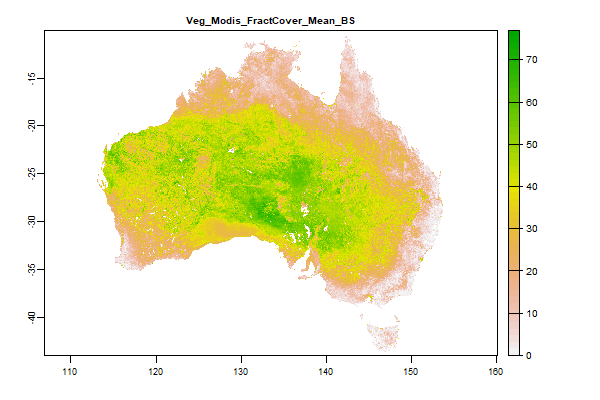 Click to enlarge the image
|
|
214.3 Mb | Veg_Modis_FractCover_Mean_BS |
Name : Veg_Modis_FractCover_Mean_BS
Description : Fractional cover - MODIS CSIRO Land and Water algorithm Australia coverage - Bare Soil - Mean
Source : CSIRO CLW
Metadata : https://shiny.esoil.io/Apps/Covariates?Attribute=Organisms&Name=Veg_Modis_FractCover_Mean_BS&Resolution=90m
Units : percent
SCORPAN : Organisms
Original Resolution : 500m
|
Fractional cover - MODIS CSIRO Land and Water algorithm Australia coverage - Bare Soil - Mean | MetaData |
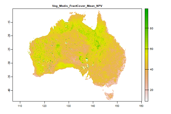 Click to enlarge the image
|
|
220.3 Mb | Veg_Modis_FractCover_Mean_NPV |
Name : Veg_Modis_FractCover_Mean_NPV
Description : Fractional cover - MODIS CSIRO Land and Water algorithm Australia coverage - Non Photosynthetic Vegetation - Mean
Source : CSIRO CLW
Metadata : https://shiny.esoil.io/Apps/Covariates?Attribute=Organisms&Name=Veg_Modis_FractCover_Mean_NPV&Resolution=90m
Units : percent
SCORPAN : Organisms
Original Resolution : 500m
|
Fractional cover - MODIS CSIRO Land and Water algorithm Australia coverage - Non Photosynthetic Vegetation - Mean | MetaData |
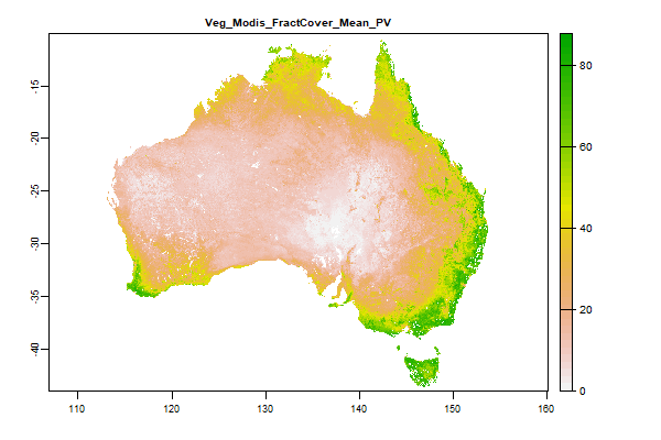 Click to enlarge the image
|
|
184.2 Mb | Veg_Modis_FractCover_Mean_PV |
Name : Veg_Modis_FractCover_Mean_PV
Description : Fractional cover - MODIS CSIRO Land and Water algorithm Australia coverage - Photosynthetic Vegetation - Mean
Source : CSIRO CLW
Metadata : https://shiny.esoil.io/Apps/Covariates?Attribute=Organisms&Name=Veg_Modis_FractCover_Mean_PV&Resolution=90m
Units : percent
SCORPAN : Organisms
Original Resolution : 500m
|
Fractional cover - MODIS CSIRO Land and Water algorithm Australia coverage - Photosynthetic Vegetation - Mean | MetaData |
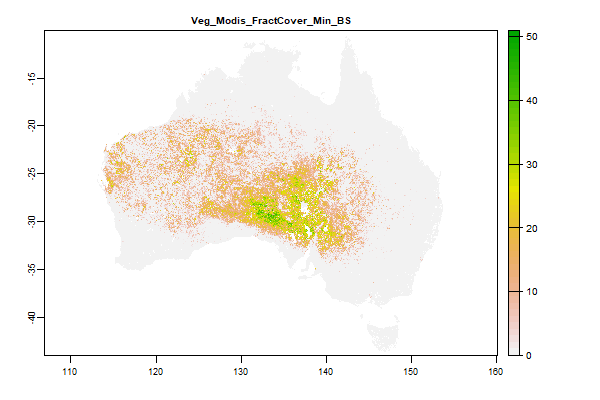 Click to enlarge the image
|
|
130.6 Mb | Veg_Modis_FractCover_Min_BS |
Name : Veg_Modis_FractCover_Min_BS
Description : Fractional cover - MODIS CSIRO Land and Water algorithm Australia coverage - Bare Soil - Minimum
Source : CSIRO CLW
Metadata : https://shiny.esoil.io/Apps/Covariates?Attribute=Organisms&Name=Veg_Modis_FractCover_Min_BS&Resolution=90m
Units : percent
SCORPAN : Organisms
Original Resolution : 500m
|
Fractional cover - MODIS CSIRO Land and Water algorithm Australia coverage - Bare Soil - Minimum | MetaData |
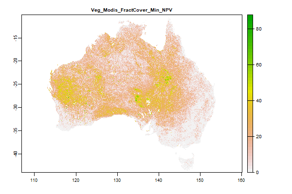 Click to enlarge the image
|
|
299.1 Mb | Veg_Modis_FractCover_Min_NPV |
Name : Veg_Modis_FractCover_Min_NPV
Description : Fractional cover - MODIS CSIRO Land and Water algorithm Australia coverage - Non Photosynthetic Vegetation - Minimum
Source : CSIRO CLW
Metadata : https://shiny.esoil.io/Apps/Covariates?Attribute=Organisms&Name=Veg_Modis_FractCover_Min_NPV&Resolution=90m
Units : percent
SCORPAN : Organisms
Original Resolution : 500m
|
Fractional cover - MODIS CSIRO Land and Water algorithm Australia coverage - Non Photosynthetic Vegetation - Minimum | MetaData |
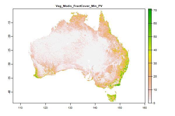 Click to enlarge the image
|
|
176.2 Mb | Veg_Modis_FractCover_Min_PV |
Name : Veg_Modis_FractCover_Min_PV
Description : Fractional cover - MODIS CSIRO Land and Water algorithm Australia coverage - Photosynthetic Vegetation - Minimum
Source : CSIRO CLW
Metadata : https://shiny.esoil.io/Apps/Covariates?Attribute=Organisms&Name=Veg_Modis_FractCover_Min_PV&Resolution=90m
Units : percent
SCORPAN : Organisms
Original Resolution : 500m
|
Fractional cover - MODIS CSIRO Land and Water algorithm Australia coverage - Photosynthetic Vegetation - Minimum | MetaData |
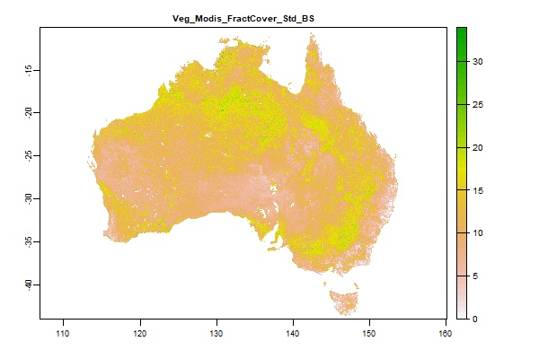 Click to enlarge the image
|
|
160.8 Mb | Veg_Modis_FractCover_Std_BS |
Name : Veg_Modis_FractCover_Std_BS
Description : Fractional cover - MODIS CSIRO Land and Water algorithm Australia coverage - Bare Soil - Standard Deviation
Source : CSIRO CLW
Metadata : https://shiny.esoil.io/Apps/Covariates?Attribute=Organisms&Name=Veg_Modis_FractCover_Std_BS&Resolution=90m
Units : percent
SCORPAN : Organisms
Original Resolution : 500m
|
Fractional cover - MODIS CSIRO Land and Water algorithm Australia coverage - Bare Soil - Standard Deviation | MetaData |
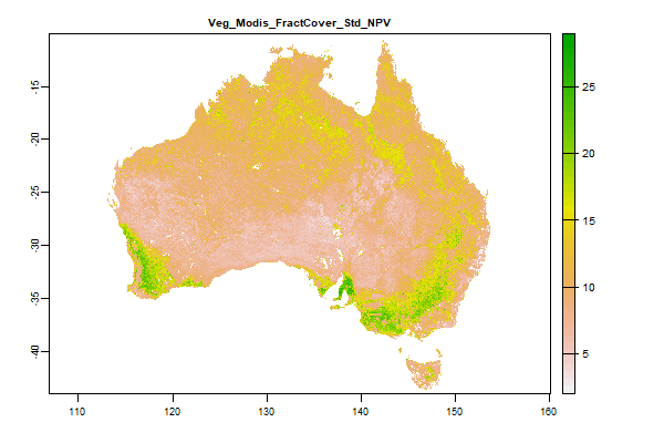 Click to enlarge the image
|
|
145.9 Mb | Veg_Modis_FractCover_Std_NPV |
Name : Veg_Modis_FractCover_Std_NPV
Description : Fractional cover - MODIS CSIRO Land and Water algorithm Australia coverage - Non Photosynthetic Vegetation - Standard Deviation
Source : CSIRO CLW
Metadata : https://shiny.esoil.io/Apps/Covariates?Attribute=Organisms&Name=Veg_Modis_FractCover_Std_NPV&Resolution=90m
Units : percent
SCORPAN : Organisms
Original Resolution : 500m
|
Fractional cover - MODIS CSIRO Land and Water algorithm Australia coverage - Non Photosynthetic Vegetation - Standard Deviation | MetaData |
 Click to enlarge the image
|
|
132.3 Mb | Veg_Modis_FractCover_Std_PV |
Name : Veg_Modis_FractCover_Std_PV
Description : Fractional cover - MODIS CSIRO Land and Water algorithm Australia coverage - Photosynthetic Vegetation - Standard Deviation
Source : CSIRO CLW
Metadata : https://shiny.esoil.io/Apps/Covariates?Attribute=Organisms&Name=Veg_Modis_FractCover_Std_PV&Resolution=90m
Units : percent
SCORPAN : Organisms
Original Resolution : 500m
|
Fractional cover - MODIS CSIRO Land and Water algorithm Australia coverage - Photosynthetic Vegetation - Standard Deviation | MetaData |
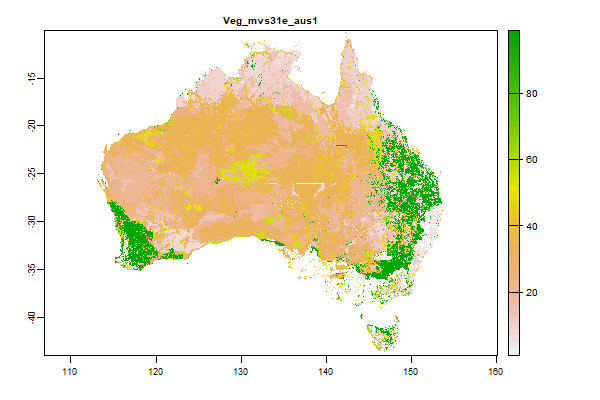 Click to enlarge the image
|
|
82 Mb | Veg_mvs31e_aus1 |
Name : Veg_mvs31e_aus1
Description : Australia - Present Major Vegetation Subgroups - NVIS Stage 1 Version 3.1
Source : Australian Government Department of the Environment and Water Resources
Metadata : https://shiny.esoil.io/Apps/Covariates?Attribute=Organisms&Name=Veg_mvs31e_aus1&Resolution=90m
Units :
SCORPAN : Organisms
Original Resolution :
|
Australia - Present Major Vegetation Subgroups - NVIS Stage 1 Version 3.1 | MetaData |
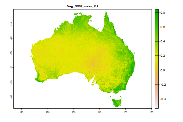 Click to enlarge the image
|
|
4.2 Gb | Veg_NDVI_mean_Q1 |
Name : Veg_NDVI_mean_Q1
Description : Long-term average Normalized Difference Vegetation Index (NDVI) values derived from could-free Landsat 8 TOA collection - https://developers.google.com/earth-engine/datasets/catalog/landsat-8 - and processed in Google Earth Engine.
Source : University of Sydney
Metadata : https://shiny.esoil.io/Apps/Covariates?Attribute=Organisms&Name=Veg_NDVI_mean_Q1&Resolution=90m
Units : index
SCORPAN : Organisms
Original Resolution : 30m
|
Long-term average Normalized Difference Vegetation Index (NDVI) values derived from could-free Landsat 8 TOA collection - https://developers.google.com/earth-engine/datasets/catalog/landsat-8 - and processed in Google Earth Engine. | MetaData |
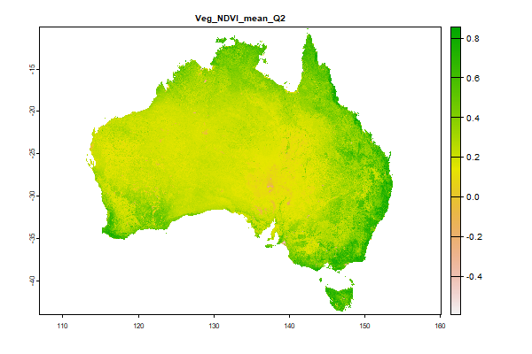 Click to enlarge the image
|
|
4.2 Gb | Veg_NDVI_mean_Q2 |
Name : Veg_NDVI_mean_Q2
Description : Long-term average Normalized Difference Vegetation Index (NDVI) values derived from could-free Landsat 8 TOA collection - https://developers.google.com/earth-engine/datasets/catalog/landsat-8 - and processed in Google Earth Engine.
Source : University of Sydney
Metadata : https://shiny.esoil.io/Apps/Covariates?Attribute=Organisms&Name=Veg_NDVI_mean_Q2&Resolution=90m
Units : index
SCORPAN : Organisms
Original Resolution : 30m
|
Long-term average Normalized Difference Vegetation Index (NDVI) values derived from could-free Landsat 8 TOA collection - https://developers.google.com/earth-engine/datasets/catalog/landsat-8 - and processed in Google Earth Engine. | MetaData |
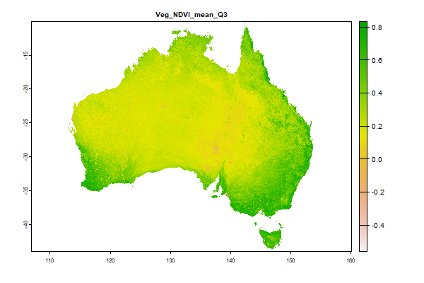 Click to enlarge the image
|
|
4.2 Gb | Veg_NDVI_mean_Q3 |
Name : Veg_NDVI_mean_Q3
Description : Long-term average Normalized Difference Vegetation Index (NDVI) values derived from could-free Landsat 8 TOA collection - https://developers.google.com/earth-engine/datasets/catalog/landsat-8 - and processed in Google Earth Engine.
Source : University of Sydney
Metadata : https://shiny.esoil.io/Apps/Covariates?Attribute=Organisms&Name=Veg_NDVI_mean_Q3&Resolution=90m
Units : index
SCORPAN : Organisms
Original Resolution : 30m
|
Long-term average Normalized Difference Vegetation Index (NDVI) values derived from could-free Landsat 8 TOA collection - https://developers.google.com/earth-engine/datasets/catalog/landsat-8 - and processed in Google Earth Engine. | MetaData |
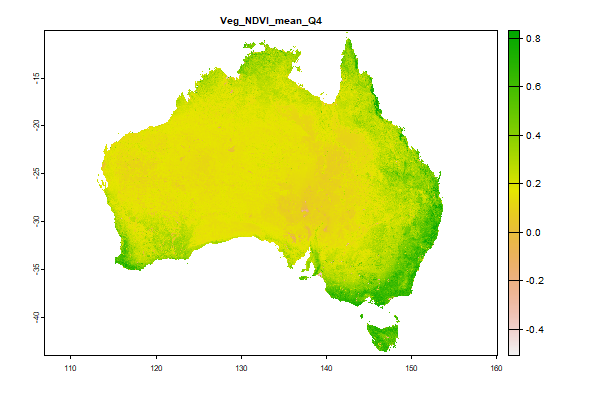 Click to enlarge the image
|
|
4.2 Gb | Veg_NDVI_mean_Q4 |
Name : Veg_NDVI_mean_Q4
Description : Long-term average Normalized Difference Vegetation Index (NDVI) values derived from could-free Landsat 8 TOA collection - https://developers.google.com/earth-engine/datasets/catalog/landsat-8 - and processed in Google Earth Engine.
Source : University of Sydney
Metadata : https://shiny.esoil.io/Apps/Covariates?Attribute=Organisms&Name=Veg_NDVI_mean_Q4&Resolution=90m
Units : index
SCORPAN : Organisms
Original Resolution : 30m
|
Long-term average Normalized Difference Vegetation Index (NDVI) values derived from could-free Landsat 8 TOA collection - https://developers.google.com/earth-engine/datasets/catalog/landsat-8 - and processed in Google Earth Engine. | MetaData |
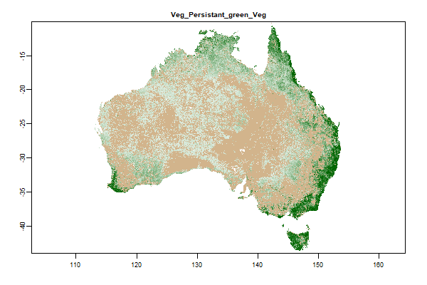 Click to enlarge the image
|
|
598.6 Mb | Veg_Persistant_green_Veg |
Name : Veg_Persistant_green_Veg
Description : Landsat 2000-2010 Persistent Green-Vegetation Fraction
Source : JRSRP
Metadata : https://shiny.esoil.io/Apps/Covariates?Attribute=Organisms&Name=Veg_Persistant_green_Veg&Resolution=90m
Units :
SCORPAN : Organisms
Original Resolution :
|
Landsat 2000-2010 Persistent Green-Vegetation Fraction | MetaData |
FundersPartners


TERN is enabled by NCRIS.